You are here: Home > Network List > US - United States National Seismic Network Stations List
> Station CBKS Cedar Bluff, Kansas, USA > Earthquake Result Viewer
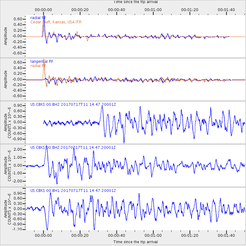
CBKS Cedar Bluff, Kansas, USA - Earthquake Result Viewer
| Earthquake location: |
Komandorskiye Ostrova Region |
| Earthquake latitude/longitude: |
54.6/168.6 |
| Earthquake time(UTC): |
2017/07/17 (198) 11:05:08 GMT |
| Earthquake Depth: |
7.9 km |
| Earthquake Magnitude: |
6.2 Mww |
| Earthquake Catalog/Contributor: |
NEIC PDE/us |
|
| Network: |
US United States National Seismic Network |
| Station: |
CBKS Cedar Bluff, Kansas, USA |
| Lat/Lon: |
38.81 N/99.74 W |
| Elevation: |
677 m |
|
| Distance: |
60.3 deg |
| Az: |
63.976 deg |
| Baz: |
317.965 deg |
| Ray Param: |
0.06159732 |
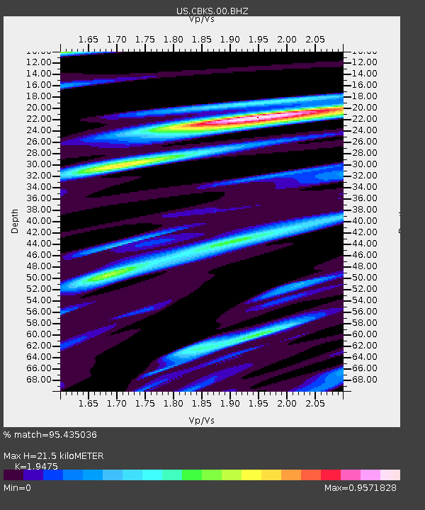
| Estimated Moho Depth: |
21.5 km |
| Estimated Crust Vp/Vs: |
1.95 |
| Assumed Crust Vp: |
6.483 km/s |
| Estimated Crust Vs: |
3.329 km/s |
| Estimated Crust Poisson's Ratio: |
0.32 |
|
| Radial Match: |
95.435036 % |
| Radial Bump: |
384 |
| Transverse Match: |
88.67083 % |
| Transverse Bump: |
400 |
| SOD ConfigId: |
2140511 |
| Insert Time: |
2017-07-31 03:02:57.949 +0000 |
| GWidth: |
2.5 |
| Max Bumps: |
400 |
| Tol: |
0.001 |
|
Signal To Noise
| Channel | StoN | STA | LTA |
| US:CBKS:00:BHZ:20170717T11:14:47.20001Z | 13.732714 | 1.1977528E-6 | 8.721895E-8 |
| US:CBKS:00:BH1:20170717T11:14:47.20001Z | 7.6169057 | 6.185583E-7 | 8.120861E-8 |
| US:CBKS:00:BH2:20170717T11:14:47.20001Z | 7.200187 | 4.485386E-7 | 6.229541E-8 |
| Arrivals |
| Ps | 3.3 SECOND |
| PpPs | 9.4 SECOND |
| PsPs/PpSs | 13 SECOND |


