You are here: Home > Network List > TA - USArray Transportable Network (new EarthScope stations) Stations List
> Station D23K Nanushuk River, AK USA > Earthquake Result Viewer
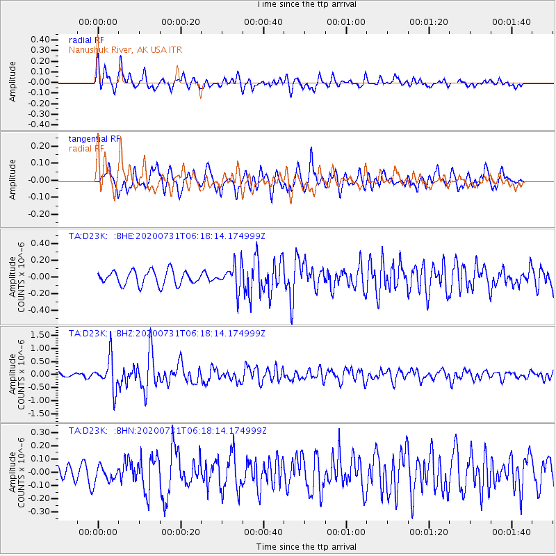
D23K Nanushuk River, AK USA - Earthquake Result Viewer
| Earthquake location: |
Mindanao, Philippines |
| Earthquake latitude/longitude: |
8.5/126.6 |
| Earthquake time(UTC): |
2020/07/31 (213) 06:06:41 GMT |
| Earthquake Depth: |
28 km |
| Earthquake Magnitude: |
5.7 Mww |
| Earthquake Catalog/Contributor: |
NEIC PDE/us |
|
| Network: |
TA USArray Transportable Network (new EarthScope stations) |
| Station: |
D23K Nanushuk River, AK USA |
| Lat/Lon: |
68.97 N/150.68 W |
| Elevation: |
406 m |
|
| Distance: |
79.5 deg |
| Az: |
21.362 deg |
| Baz: |
266.291 deg |
| Ray Param: |
0.048912376 |
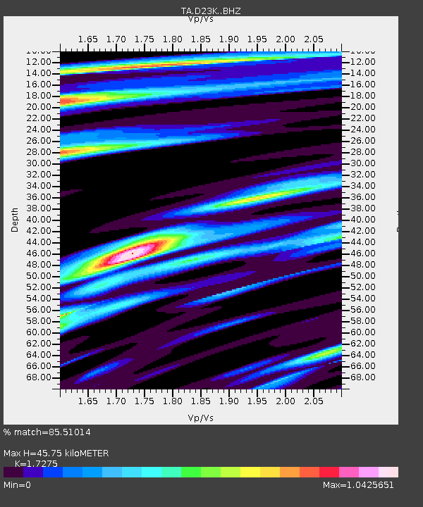
| Estimated Moho Depth: |
45.75 km |
| Estimated Crust Vp/Vs: |
1.73 |
| Assumed Crust Vp: |
6.221 km/s |
| Estimated Crust Vs: |
3.601 km/s |
| Estimated Crust Poisson's Ratio: |
0.25 |
|
| Radial Match: |
85.51014 % |
| Radial Bump: |
400 |
| Transverse Match: |
83.14303 % |
| Transverse Bump: |
400 |
| SOD ConfigId: |
21709731 |
| Insert Time: |
2020-08-14 06:18:45.001 +0000 |
| GWidth: |
2.5 |
| Max Bumps: |
400 |
| Tol: |
0.001 |
|
Signal To Noise
| Channel | StoN | STA | LTA |
| TA:D23K: :BHZ:20200731T06:18:14.174999Z | 6.635973 | 6.343216E-7 | 9.558834E-8 |
| TA:D23K: :BHN:20200731T06:18:14.174999Z | 0.9669089 | 5.1671655E-8 | 5.3440047E-8 |
| TA:D23K: :BHE:20200731T06:18:14.174999Z | 1.8505116 | 1.556483E-7 | 8.411095E-8 |
| Arrivals |
| Ps | 5.5 SECOND |
| PpPs | 20 SECOND |
| PsPs/PpSs | 25 SECOND |


