You are here: Home > Network List > TA - USArray Transportable Network (new EarthScope stations) Stations List
> Station F21K Alatna River, AK, USA > Earthquake Result Viewer
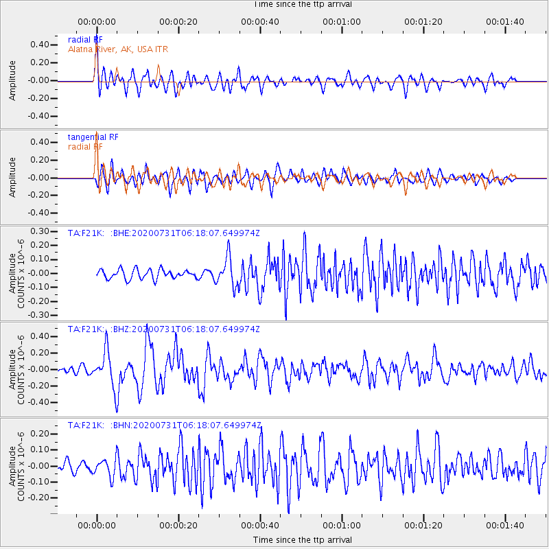
F21K Alatna River, AK, USA - Earthquake Result Viewer
*The percent match for this event was below the threshold and hence no stack was calculated.
| Earthquake location: |
Mindanao, Philippines |
| Earthquake latitude/longitude: |
8.5/126.6 |
| Earthquake time(UTC): |
2020/07/31 (213) 06:06:41 GMT |
| Earthquake Depth: |
28 km |
| Earthquake Magnitude: |
5.7 Mww |
| Earthquake Catalog/Contributor: |
NEIC PDE/us |
|
| Network: |
TA USArray Transportable Network (new EarthScope stations) |
| Station: |
F21K Alatna River, AK, USA |
| Lat/Lon: |
67.22 N/153.48 W |
| Elevation: |
597 m |
|
| Distance: |
78.3 deg |
| Az: |
23.05 deg |
| Baz: |
264.019 deg |
| Ray Param: |
$rayparam |
*The percent match for this event was below the threshold and hence was not used in the summary stack. |
|
| Radial Match: |
75.85334 % |
| Radial Bump: |
400 |
| Transverse Match: |
66.25567 % |
| Transverse Bump: |
400 |
| SOD ConfigId: |
21709731 |
| Insert Time: |
2020-08-14 06:19:16.736 +0000 |
| GWidth: |
2.5 |
| Max Bumps: |
400 |
| Tol: |
0.001 |
|
Signal To Noise
| Channel | StoN | STA | LTA |
| TA:F21K: :BHZ:20200731T06:18:07.649974Z | 5.1708493 | 2.3194922E-7 | 4.485708E-8 |
| TA:F21K: :BHN:20200731T06:18:07.649974Z | 1.5711799 | 5.8050308E-8 | 3.694695E-8 |
| TA:F21K: :BHE:20200731T06:18:07.649974Z | 3.2412322 | 1.0571105E-7 | 3.2614466E-8 |
| Arrivals |
| Ps | |
| PpPs | |
| PsPs/PpSs | |


