You are here: Home > Network List > TA - USArray Transportable Network (new EarthScope stations) Stations List
> Station G27K Doyon Strip, AK, USA > Earthquake Result Viewer
G27K Doyon Strip, AK, USA - Earthquake Result Viewer
| Earthquake location: |
Mindanao, Philippines |
| Earthquake latitude/longitude: |
8.5/126.6 |
| Earthquake time(UTC): |
2020/07/31 (213) 06:06:41 GMT |
| Earthquake Depth: |
28 km |
| Earthquake Magnitude: |
5.7 Mww |
| Earthquake Catalog/Contributor: |
NEIC PDE/us |
|
| Network: |
TA USArray Transportable Network (new EarthScope stations) |
| Station: |
G27K Doyon Strip, AK, USA |
| Lat/Lon: |
66.81 N/141.65 W |
| Elevation: |
686 m |
|
| Distance: |
82.9 deg |
| Az: |
23.51 deg |
| Baz: |
274.978 deg |
| Ray Param: |
0.04653515 |
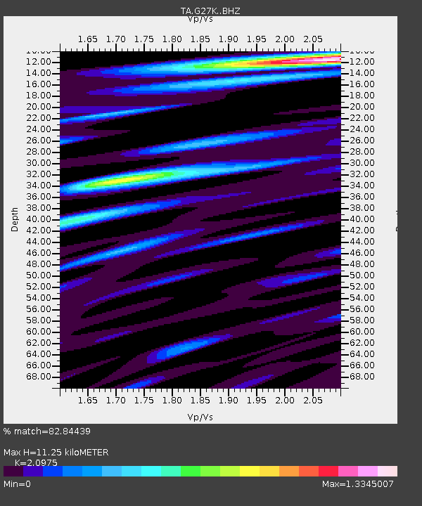
| Estimated Moho Depth: |
11.25 km |
| Estimated Crust Vp/Vs: |
2.10 |
| Assumed Crust Vp: |
6.577 km/s |
| Estimated Crust Vs: |
3.136 km/s |
| Estimated Crust Poisson's Ratio: |
0.35 |
|
| Radial Match: |
82.84439 % |
| Radial Bump: |
400 |
| Transverse Match: |
81.04784 % |
| Transverse Bump: |
400 |
| SOD ConfigId: |
21709731 |
| Insert Time: |
2020-08-14 06:19:51.071 +0000 |
| GWidth: |
2.5 |
| Max Bumps: |
400 |
| Tol: |
0.001 |
|

Signal To Noise
| Channel | StoN | STA | LTA |
| TA:G27K: :BHZ:20200731T06:18:32.375011Z | 9.789836 | 4.3338505E-7 | 4.426888E-8 |
| TA:G27K: :BHN:20200731T06:18:32.375011Z | 2.0040095 | 7.292504E-8 | 3.6389565E-8 |
| TA:G27K: :BHE:20200731T06:18:32.375011Z | 2.6185348 | 1.2061837E-7 | 4.6063306E-8 |
| Arrivals |
| Ps | 1.9 SECOND |
| PpPs | 5.2 SECOND |
| PsPs/PpSs | 7.1 SECOND |


