You are here: Home > Network List > TA - USArray Transportable Network (new EarthScope stations) Stations List
> Station L16K Owhat River, AK, USA > Earthquake Result Viewer
L16K Owhat River, AK, USA - Earthquake Result Viewer
| Earthquake location: |
Mindanao, Philippines |
| Earthquake latitude/longitude: |
8.5/126.6 |
| Earthquake time(UTC): |
2020/07/31 (213) 06:06:41 GMT |
| Earthquake Depth: |
28 km |
| Earthquake Magnitude: |
5.7 Mww |
| Earthquake Catalog/Contributor: |
NEIC PDE/us |
|
| Network: |
TA USArray Transportable Network (new EarthScope stations) |
| Station: |
L16K Owhat River, AK, USA |
| Lat/Lon: |
61.71 N/159.47 W |
| Elevation: |
227 m |
|
| Distance: |
74.9 deg |
| Az: |
28.301 deg |
| Baz: |
259.831 deg |
| Ray Param: |
0.05197723 |
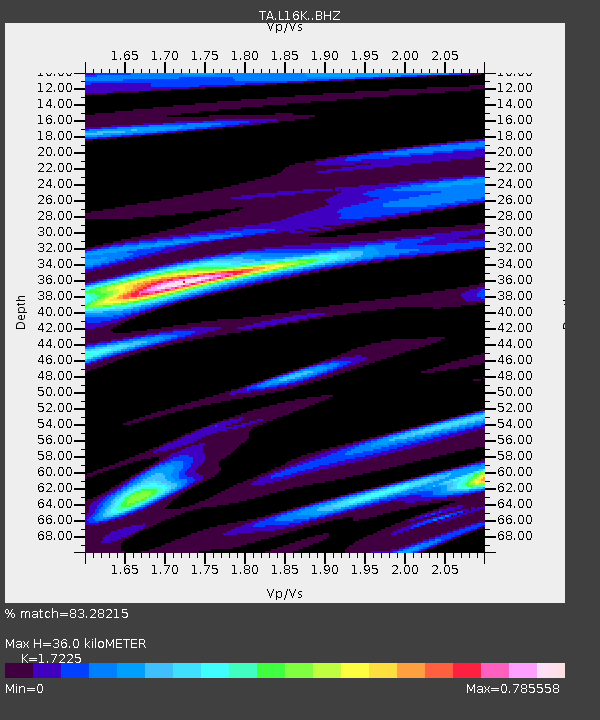
| Estimated Moho Depth: |
36.0 km |
| Estimated Crust Vp/Vs: |
1.72 |
| Assumed Crust Vp: |
6.276 km/s |
| Estimated Crust Vs: |
3.643 km/s |
| Estimated Crust Poisson's Ratio: |
0.25 |
|
| Radial Match: |
83.28215 % |
| Radial Bump: |
354 |
| Transverse Match: |
68.27953 % |
| Transverse Bump: |
400 |
| SOD ConfigId: |
21709731 |
| Insert Time: |
2020-08-14 06:20:30.083 +0000 |
| GWidth: |
2.5 |
| Max Bumps: |
400 |
| Tol: |
0.001 |
|

Signal To Noise
| Channel | StoN | STA | LTA |
| TA:L16K: :BHZ:20200731T06:17:48.750011Z | 9.271538 | 5.8198475E-7 | 6.2771115E-8 |
| TA:L16K: :BHN:20200731T06:17:48.750011Z | 0.7667933 | 5.8129547E-8 | 7.580863E-8 |
| TA:L16K: :BHE:20200731T06:17:48.750011Z | 2.9910064 | 2.5443714E-7 | 8.5067406E-8 |
| Arrivals |
| Ps | 4.3 SECOND |
| PpPs | 15 SECOND |
| PsPs/PpSs | 19 SECOND |


