You are here: Home > Network List > US - United States National Seismic Network Stations List
> Station OGNE Ogallala, Nebraska, USA > Earthquake Result Viewer
OGNE Ogallala, Nebraska, USA - Earthquake Result Viewer
| Earthquake location: |
Komandorskiye Ostrova Region |
| Earthquake latitude/longitude: |
54.6/168.6 |
| Earthquake time(UTC): |
2017/07/17 (198) 11:05:08 GMT |
| Earthquake Depth: |
7.9 km |
| Earthquake Magnitude: |
6.2 Mww |
| Earthquake Catalog/Contributor: |
NEIC PDE/us |
|
| Network: |
US United States National Seismic Network |
| Station: |
OGNE Ogallala, Nebraska, USA |
| Lat/Lon: |
40.95 N/102.03 W |
| Elevation: |
1054 m |
|
| Distance: |
57.6 deg |
| Az: |
63.8 deg |
| Baz: |
316.408 deg |
| Ray Param: |
0.06340157 |
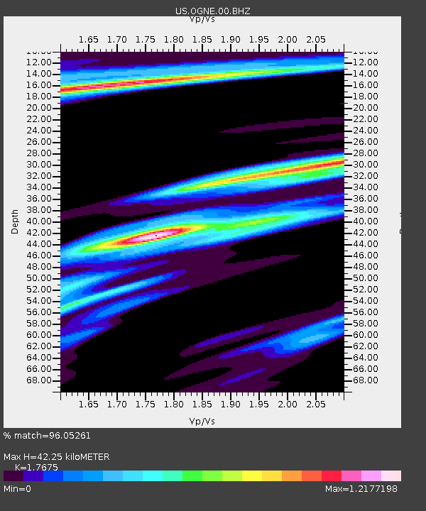
| Estimated Moho Depth: |
42.25 km |
| Estimated Crust Vp/Vs: |
1.77 |
| Assumed Crust Vp: |
6.483 km/s |
| Estimated Crust Vs: |
3.668 km/s |
| Estimated Crust Poisson's Ratio: |
0.26 |
|
| Radial Match: |
96.05261 % |
| Radial Bump: |
326 |
| Transverse Match: |
80.64314 % |
| Transverse Bump: |
307 |
| SOD ConfigId: |
2140511 |
| Insert Time: |
2017-07-31 03:03:52.807 +0000 |
| GWidth: |
2.5 |
| Max Bumps: |
400 |
| Tol: |
0.001 |
|
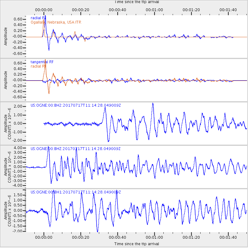
Signal To Noise
| Channel | StoN | STA | LTA |
| US:OGNE:00:BHZ:20170717T11:14:28.049009Z | 26.624521 | 2.0792604E-6 | 7.8095695E-8 |
| US:OGNE:00:BH1:20170717T11:14:28.049009Z | 7.3720155 | 7.138361E-7 | 9.683052E-8 |
| US:OGNE:00:BH2:20170717T11:14:28.049009Z | 9.705139 | 9.0195664E-7 | 9.2935984E-8 |
| Arrivals |
| Ps | 5.3 SECOND |
| PpPs | 17 SECOND |
| PsPs/PpSs | 22 SECOND |


