You are here: Home > Network List > UU - University of Utah Regional Network Stations List
> Station BGU Big Grassy Mountain, UT, USA > Earthquake Result Viewer
BGU Big Grassy Mountain, UT, USA - Earthquake Result Viewer
| Earthquake location: |
Komandorskiye Ostrova Region |
| Earthquake latitude/longitude: |
54.6/168.6 |
| Earthquake time(UTC): |
2017/07/17 (198) 11:05:08 GMT |
| Earthquake Depth: |
7.9 km |
| Earthquake Magnitude: |
6.2 Mww |
| Earthquake Catalog/Contributor: |
NEIC PDE/us |
|
| Network: |
UU University of Utah Regional Network |
| Station: |
BGU Big Grassy Mountain, UT, USA |
| Lat/Lon: |
40.92 N/113.03 W |
| Elevation: |
1640 m |
|
| Distance: |
51.7 deg |
| Az: |
71.027 deg |
| Baz: |
313.41 deg |
| Ray Param: |
0.0672501 |
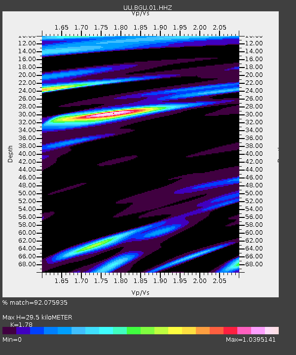
| Estimated Moho Depth: |
29.5 km |
| Estimated Crust Vp/Vs: |
1.78 |
| Assumed Crust Vp: |
6.276 km/s |
| Estimated Crust Vs: |
3.526 km/s |
| Estimated Crust Poisson's Ratio: |
0.27 |
|
| Radial Match: |
92.075935 % |
| Radial Bump: |
400 |
| Transverse Match: |
80.53303 % |
| Transverse Bump: |
400 |
| SOD ConfigId: |
2140511 |
| Insert Time: |
2017-07-31 03:04:07.051 +0000 |
| GWidth: |
2.5 |
| Max Bumps: |
400 |
| Tol: |
0.001 |
|

Signal To Noise
| Channel | StoN | STA | LTA |
| UU:BGU:01:HHZ:20170717T11:13:45.398008Z | 15.741193 | 3.426704E-8 | 2.1769024E-9 |
| UU:BGU:01:HHN:20170717T11:13:45.398008Z | 7.356207 | 1.2031909E-8 | 1.6356132E-9 |
| UU:BGU:01:HHE:20170717T11:13:45.398008Z | 7.595126 | 1.4533434E-8 | 1.9135211E-9 |
| Arrivals |
| Ps | 3.9 SECOND |
| PpPs | 12 SECOND |
| PsPs/PpSs | 16 SECOND |


