You are here: Home > Network List > AV - Alaska Volcano Observatory Stations List
> Station AUSS Augustine Summit Station, Augustine Volcano, Alaska > Earthquake Result Viewer
AUSS Augustine Summit Station, Augustine Volcano, Alaska - Earthquake Result Viewer
| Earthquake location: |
Mindanao, Philippines |
| Earthquake latitude/longitude: |
7.3/124.1 |
| Earthquake time(UTC): |
2020/08/01 (214) 17:09:01 GMT |
| Earthquake Depth: |
480 km |
| Earthquake Magnitude: |
6.4 mww |
| Earthquake Catalog/Contributor: |
NEIC PDE/us |
|
| Network: |
AV Alaska Volcano Observatory |
| Station: |
AUSS Augustine Summit Station, Augustine Volcano, Alaska |
| Lat/Lon: |
59.36 N/153.43 W |
| Elevation: |
1235 m |
|
| Distance: |
79.9 deg |
| Az: |
31.046 deg |
| Baz: |
267.229 deg |
| Ray Param: |
0.04725076 |
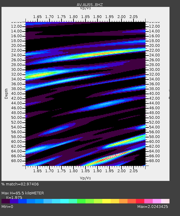
| Estimated Moho Depth: |
65.5 km |
| Estimated Crust Vp/Vs: |
1.98 |
| Assumed Crust Vp: |
5.989 km/s |
| Estimated Crust Vs: |
3.032 km/s |
| Estimated Crust Poisson's Ratio: |
0.33 |
|
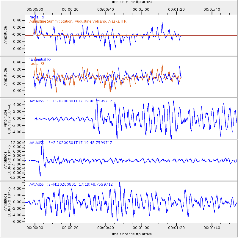
| Radial Match: |
82.97406 % |
| Radial Bump: |
296 |
| Transverse Match: |
71.89573 % |
| Transverse Bump: |
367 |
| SOD ConfigId: |
21709731 |
| Insert Time: |
2020-08-15 17:13:57.468 +0000 |
| GWidth: |
2.5 |
| Max Bumps: |
400 |
| Tol: |
0.001 |
|
Signal To Noise
| Channel | StoN | STA | LTA |
| AV:AUSS: :BHZ:20200801T17:19:48.759971Z | 52.64233 | 6.069108E-6 | 1.1528951E-7 |
| AV:AUSS: :BHN:20200801T17:19:48.759971Z | 3.1669288 | 1.249465E-6 | 3.9453522E-7 |
| AV:AUSS: :BHE:20200801T17:19:48.759971Z | 5.821251 | 1.583003E-6 | 2.719352E-7 |
| Arrivals |
| Ps | 11 SECOND |
| PpPs | 32 SECOND |
| PsPs/PpSs | 43 SECOND |


