You are here: Home > Network List > AV - Alaska Volcano Observatory Stations List
> Station MAPS Pakushin Southeast, Makushin Volcano, Alaska > Earthquake Result Viewer
MAPS Pakushin Southeast, Makushin Volcano, Alaska - Earthquake Result Viewer
| Earthquake location: |
Mindanao, Philippines |
| Earthquake latitude/longitude: |
7.3/124.1 |
| Earthquake time(UTC): |
2020/08/01 (214) 17:09:01 GMT |
| Earthquake Depth: |
480 km |
| Earthquake Magnitude: |
6.4 mww |
| Earthquake Catalog/Contributor: |
NEIC PDE/us |
|
| Network: |
AV Alaska Volcano Observatory |
| Station: |
MAPS Pakushin Southeast, Makushin Volcano, Alaska |
| Lat/Lon: |
53.81 N/166.94 W |
| Elevation: |
333 m |
|
| Distance: |
71.7 deg |
| Az: |
35.642 deg |
| Baz: |
257.076 deg |
| Ray Param: |
0.052603763 |
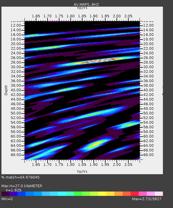
| Estimated Moho Depth: |
27.0 km |
| Estimated Crust Vp/Vs: |
1.92 |
| Assumed Crust Vp: |
3.943 km/s |
| Estimated Crust Vs: |
2.049 km/s |
| Estimated Crust Poisson's Ratio: |
0.32 |
|
| Radial Match: |
84.976845 % |
| Radial Bump: |
400 |
| Transverse Match: |
80.34307 % |
| Transverse Bump: |
400 |
| SOD ConfigId: |
21709731 |
| Insert Time: |
2020-08-15 17:14:55.125 +0000 |
| GWidth: |
2.5 |
| Max Bumps: |
400 |
| Tol: |
0.001 |
|

Signal To Noise
| Channel | StoN | STA | LTA |
| AV:MAPS: :BHZ:20200801T17:19:03.618979Z | 8.118692 | 7.605976E-7 | 9.368474E-8 |
| AV:MAPS: :BHN:20200801T17:19:03.618979Z | 6.1861057 | 4.082378E-7 | 6.59927E-8 |
| AV:MAPS: :BHE:20200801T17:19:03.618979Z | 14.145746 | 1.0589232E-6 | 7.485807E-8 |
| Arrivals |
| Ps | 6.4 SECOND |
| PpPs | 20 SECOND |
| PsPs/PpSs | 26 SECOND |


