You are here: Home > Network List > HL - National Observatory of Athens Digital Broadband Network Stations List
> Station ITM ITHOMI, GREECE > Earthquake Result Viewer
ITM ITHOMI, GREECE - Earthquake Result Viewer
| Earthquake location: |
Mindanao, Philippines |
| Earthquake latitude/longitude: |
7.3/124.1 |
| Earthquake time(UTC): |
2020/08/01 (214) 17:09:01 GMT |
| Earthquake Depth: |
480 km |
| Earthquake Magnitude: |
6.4 mww |
| Earthquake Catalog/Contributor: |
NEIC PDE/us |
|
| Network: |
HL National Observatory of Athens Digital Broadband Network |
| Station: |
ITM ITHOMI, GREECE |
| Lat/Lon: |
37.18 N/21.93 E |
| Elevation: |
400 m |
|
| Distance: |
95.3 deg |
| Az: |
308.379 deg |
| Baz: |
76.812 deg |
| Ray Param: |
0.04036935 |
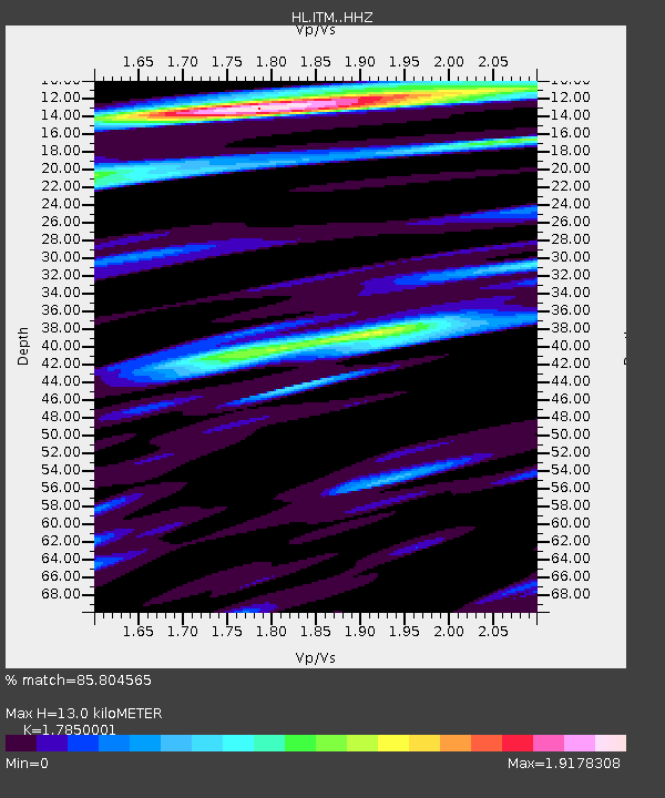
| Estimated Moho Depth: |
13.0 km |
| Estimated Crust Vp/Vs: |
1.79 |
| Assumed Crust Vp: |
5.627 km/s |
| Estimated Crust Vs: |
3.152 km/s |
| Estimated Crust Poisson's Ratio: |
0.27 |
|
| Radial Match: |
85.804565 % |
| Radial Bump: |
400 |
| Transverse Match: |
76.89023 % |
| Transverse Bump: |
400 |
| SOD ConfigId: |
21709731 |
| Insert Time: |
2020-08-15 17:17:36.987 +0000 |
| GWidth: |
2.5 |
| Max Bumps: |
400 |
| Tol: |
0.001 |
|

Signal To Noise
| Channel | StoN | STA | LTA |
| HL:ITM: :HHZ:20200801T17:21:01.959983Z | 44.981705 | 3.6309755E-6 | 8.072116E-8 |
| HL:ITM: :HHN:20200801T17:21:01.959983Z | 12.485408 | 1.0060926E-6 | 8.058147E-8 |
| HL:ITM: :HHE:20200801T17:21:01.959983Z | 16.127888 | 1.4488752E-6 | 8.983663E-8 |
| Arrivals |
| Ps | 1.8 SECOND |
| PpPs | 6.3 SECOND |
| PsPs/PpSs | 8.2 SECOND |


