You are here: Home > Network List > TX - Texas Seismological Network Stations List
> Station FW13 Cleburne > Earthquake Result Viewer
FW13 Cleburne - Earthquake Result Viewer
| Earthquake location: |
Komandorskiye Ostrova Region |
| Earthquake latitude/longitude: |
54.6/168.6 |
| Earthquake time(UTC): |
2017/07/17 (198) 11:05:08 GMT |
| Earthquake Depth: |
7.9 km |
| Earthquake Magnitude: |
6.2 Mww |
| Earthquake Catalog/Contributor: |
NEIC PDE/us |
|
| Network: |
TX Texas Seismological Network |
| Station: |
FW13 Cleburne |
| Lat/Lon: |
32.35 N/97.43 W |
| Elevation: |
259 m |
|
| Distance: |
66.5 deg |
| Az: |
67.078 deg |
| Baz: |
320.694 deg |
| Ray Param: |
0.057603437 |
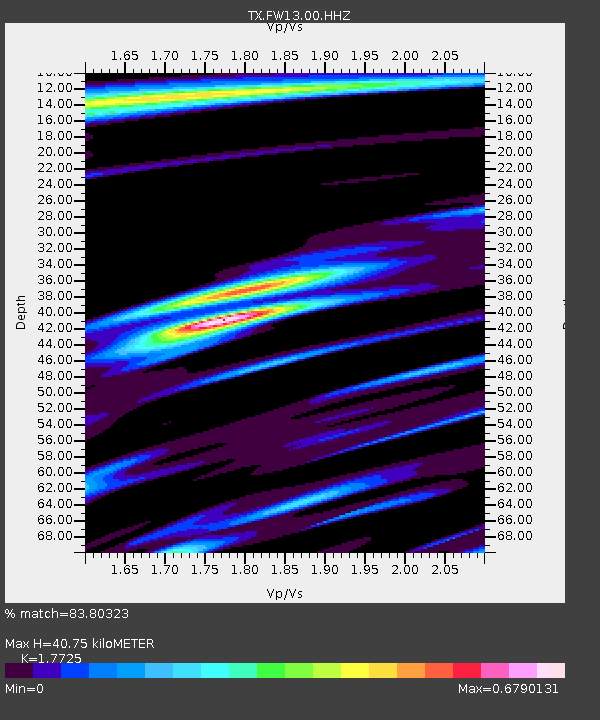
| Estimated Moho Depth: |
40.75 km |
| Estimated Crust Vp/Vs: |
1.77 |
| Assumed Crust Vp: |
6.38 km/s |
| Estimated Crust Vs: |
3.6 km/s |
| Estimated Crust Poisson's Ratio: |
0.27 |
|
| Radial Match: |
83.80323 % |
| Radial Bump: |
400 |
| Transverse Match: |
81.160324 % |
| Transverse Bump: |
400 |
| SOD ConfigId: |
2140511 |
| Insert Time: |
2017-07-31 03:05:29.181 +0000 |
| GWidth: |
2.5 |
| Max Bumps: |
400 |
| Tol: |
0.001 |
|

Signal To Noise
| Channel | StoN | STA | LTA |
| TX:FW13:00:HHZ:20170717T11:15:27.590024Z | 11.616417 | 1.0254666E-6 | 8.827735E-8 |
| TX:FW13:00:HH1:20170717T11:15:27.590024Z | 6.7835736 | 3.0080736E-7 | 4.4343494E-8 |
| TX:FW13:00:HH2:20170717T11:15:27.590024Z | 7.6218324 | 4.2640357E-7 | 5.594502E-8 |
| Arrivals |
| Ps | 5.1 SECOND |
| PpPs | 17 SECOND |
| PsPs/PpSs | 22 SECOND |


