You are here: Home > Network List > XN00 - RPI-UW Parkfield Calibration Array Stations List
> Station MRED XN.MRED > Earthquake Result Viewer
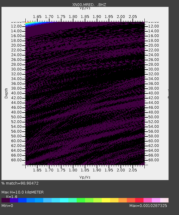
MRED XN.MRED - Earthquake Result Viewer
| Earthquake location: |
Eastern Honshu, Japan |
| Earthquake latitude/longitude: |
39.4/141.1 |
| Earthquake time(UTC): |
2001/12/02 (336) 13:01:53 GMT |
| Earthquake Depth: |
124 km |
| Earthquake Magnitude: |
6.1 MB, 6.5 MW, 6.5 MW |
| Earthquake Catalog/Contributor: |
WHDF/NEIC |
|
| Network: |
XN RPI-UW Parkfield Calibration Array |
| Station: |
MRED XN.MRED |
| Lat/Lon: |
35.96 N/120.48 W |
| Elevation: |
608 m |
|
| Distance: |
73.9 deg |
| Az: |
56.648 deg |
| Baz: |
307.082 deg |
| Ray Param: |
0.0523945 |
| Estimated Moho Depth: |
10.0 km |
| Estimated Crust Vp/Vs: |
1.60 |
| Assumed Crust Vp: |
6.183 km/s |
| Estimated Crust Vs: |
3.864 km/s |
| Estimated Crust Poisson's Ratio: |
0.18 |
|
| Radial Match: |
98.98472 % |
| Radial Bump: |
36 |
| Transverse Match: |
92.21686 % |
| Transverse Bump: |
69 |
| SOD ConfigId: |
16820 |
| Insert Time: |
2010-03-08 23:22:09.871 +0000 |
| GWidth: |
2.5 |
| Max Bumps: |
400 |
| Tol: |
0.001 |
|

Signal To Noise
| Channel | StoN | STA | LTA |
| XN:MRED: :BHZ:20011202T13:12:44.125017Z | 1.6706835 | 8.148261E-7 | 4.877202E-7 |
| XN:MRED: :BHN:20011202T13:12:44.125017Z | 0.73510474 | 1.1965406E-6 | 1.6277143E-6 |
| XN:MRED: :BHE:20011202T13:12:44.125017Z | 0.73548436 | 6.984392E-7 | 9.4963156E-7 |
| Arrivals |
| Ps | 1.0 SECOND |
| PpPs | 4.1 SECOND |
| PsPs/PpSs | 5.1 SECOND |


