You are here: Home > Network List > XN00 - RPI-UW Parkfield Calibration Array Stations List
> Station MRED XN.MRED > Earthquake Result Viewer
MRED XN.MRED - Earthquake Result Viewer
| Earthquake location: |
Tonga Islands |
| Earthquake latitude/longitude: |
-16.2/-173.8 |
| Earthquake time(UTC): |
2001/10/02 (275) 00:48:18 GMT |
| Earthquake Depth: |
107 km |
| Earthquake Magnitude: |
5.8 MB, 6.2 MW, 6.1 MW |
| Earthquake Catalog/Contributor: |
WHDF/NEIC |
|
| Network: |
XN RPI-UW Parkfield Calibration Array |
| Station: |
MRED XN.MRED |
| Lat/Lon: |
35.96 N/120.48 W |
| Elevation: |
608 m |
|
| Distance: |
72.3 deg |
| Az: |
43.076 deg |
| Baz: |
233.992 deg |
| Ray Param: |
0.053470436 |
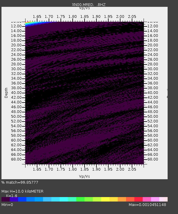
| Estimated Moho Depth: |
10.0 km |
| Estimated Crust Vp/Vs: |
1.60 |
| Assumed Crust Vp: |
6.183 km/s |
| Estimated Crust Vs: |
3.864 km/s |
| Estimated Crust Poisson's Ratio: |
0.18 |
|
| Radial Match: |
99.85777 % |
| Radial Bump: |
12 |
| Transverse Match: |
99.11881 % |
| Transverse Bump: |
37 |
| SOD ConfigId: |
16820 |
| Insert Time: |
2010-03-08 23:22:12.139 +0000 |
| GWidth: |
2.5 |
| Max Bumps: |
400 |
| Tol: |
0.001 |
|

Signal To Noise
| Channel | StoN | STA | LTA |
| XN:MRED: :BHZ:20011002T00:59:02.024009Z | 0.70582056 | 7.8696434E-7 | 1.1149639E-6 |
| XN:MRED: :BHN:20011002T00:59:02.024009Z | 1.0615162 | 5.9322235E-7 | 5.5884436E-7 |
| XN:MRED: :BHE:20011002T00:59:02.024009Z | 0.7045162 | 7.857585E-7 | 1.1153164E-6 |
| Arrivals |
| Ps | 1.0 SECOND |
| PpPs | 4.1 SECOND |
| PsPs/PpSs | 5.1 SECOND |


