You are here: Home > Network List > TA - USArray Transportable Network (new EarthScope stations) Stations List
> Station E18K Tukpahlearik Creek, AK, USA > Earthquake Result Viewer
E18K Tukpahlearik Creek, AK, USA - Earthquake Result Viewer
| Earthquake location: |
Mindanao, Philippines |
| Earthquake latitude/longitude: |
7.3/124.1 |
| Earthquake time(UTC): |
2020/08/01 (214) 17:09:01 GMT |
| Earthquake Depth: |
480 km |
| Earthquake Magnitude: |
6.4 mww |
| Earthquake Catalog/Contributor: |
NEIC PDE/us |
|
| Network: |
TA USArray Transportable Network (new EarthScope stations) |
| Station: |
E18K Tukpahlearik Creek, AK, USA |
| Lat/Lon: |
67.42 N/160.60 W |
| Elevation: |
297 m |
|
| Distance: |
77.6 deg |
| Az: |
22.476 deg |
| Baz: |
259.135 deg |
| Ray Param: |
0.048750162 |
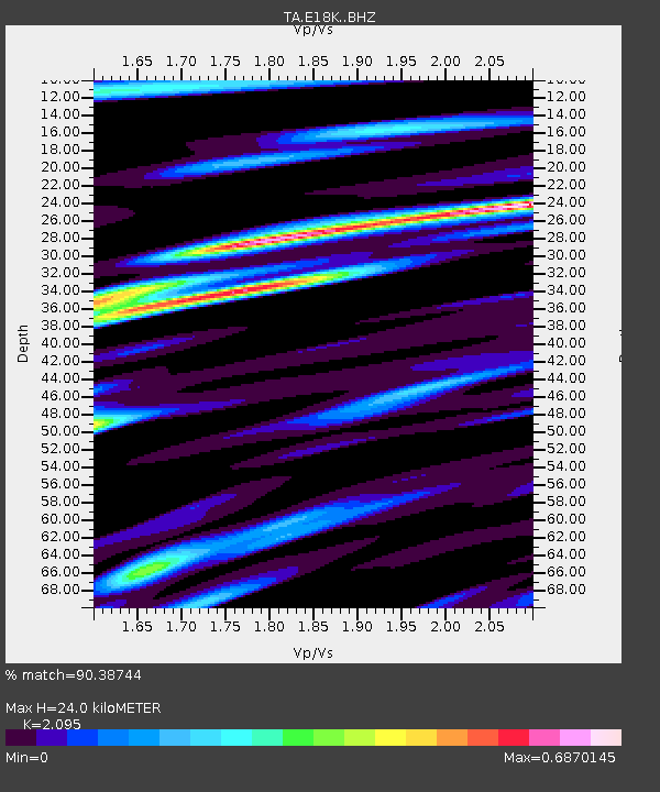
| Estimated Moho Depth: |
24.0 km |
| Estimated Crust Vp/Vs: |
2.10 |
| Assumed Crust Vp: |
6.276 km/s |
| Estimated Crust Vs: |
2.996 km/s |
| Estimated Crust Poisson's Ratio: |
0.35 |
|
| Radial Match: |
90.38744 % |
| Radial Bump: |
400 |
| Transverse Match: |
89.37675 % |
| Transverse Bump: |
400 |
| SOD ConfigId: |
21709731 |
| Insert Time: |
2020-08-15 17:21:58.348 +0000 |
| GWidth: |
2.5 |
| Max Bumps: |
400 |
| Tol: |
0.001 |
|
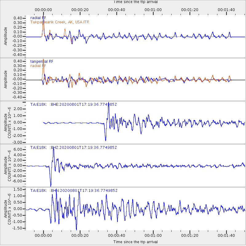
Signal To Noise
| Channel | StoN | STA | LTA |
| TA:E18K: :BHZ:20200801T17:19:36.774985Z | 47.877983 | 2.4284282E-6 | 5.072119E-8 |
| TA:E18K: :BHN:20200801T17:19:36.774985Z | 14.141779 | 4.0022354E-7 | 2.8300793E-8 |
| TA:E18K: :BHE:20200801T17:19:36.774985Z | 20.053694 | 8.493336E-7 | 4.2352976E-8 |
| Arrivals |
| Ps | 4.3 SECOND |
| PpPs | 12 SECOND |
| PsPs/PpSs | 16 SECOND |


