You are here: Home > Network List > TA - USArray Transportable Network (new EarthScope stations) Stations List
> Station F21K Alatna River, AK, USA > Earthquake Result Viewer
F21K Alatna River, AK, USA - Earthquake Result Viewer
| Earthquake location: |
Mindanao, Philippines |
| Earthquake latitude/longitude: |
7.3/124.1 |
| Earthquake time(UTC): |
2020/08/01 (214) 17:09:01 GMT |
| Earthquake Depth: |
480 km |
| Earthquake Magnitude: |
6.4 mww |
| Earthquake Catalog/Contributor: |
NEIC PDE/us |
|
| Network: |
TA USArray Transportable Network (new EarthScope stations) |
| Station: |
F21K Alatna River, AK, USA |
| Lat/Lon: |
67.22 N/153.48 W |
| Elevation: |
597 m |
|
| Distance: |
80.4 deg |
| Az: |
23.046 deg |
| Baz: |
265.808 deg |
| Ray Param: |
0.046943832 |
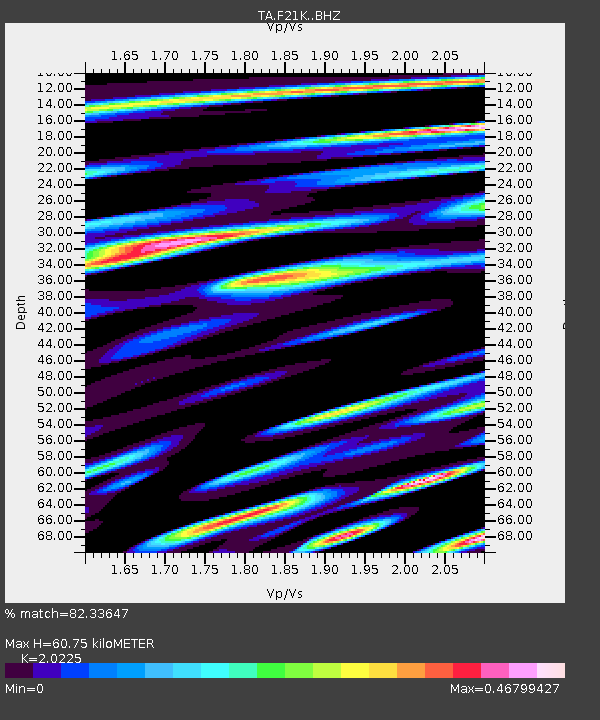
| Estimated Moho Depth: |
60.75 km |
| Estimated Crust Vp/Vs: |
2.02 |
| Assumed Crust Vp: |
6.455 km/s |
| Estimated Crust Vs: |
3.192 km/s |
| Estimated Crust Poisson's Ratio: |
0.34 |
|
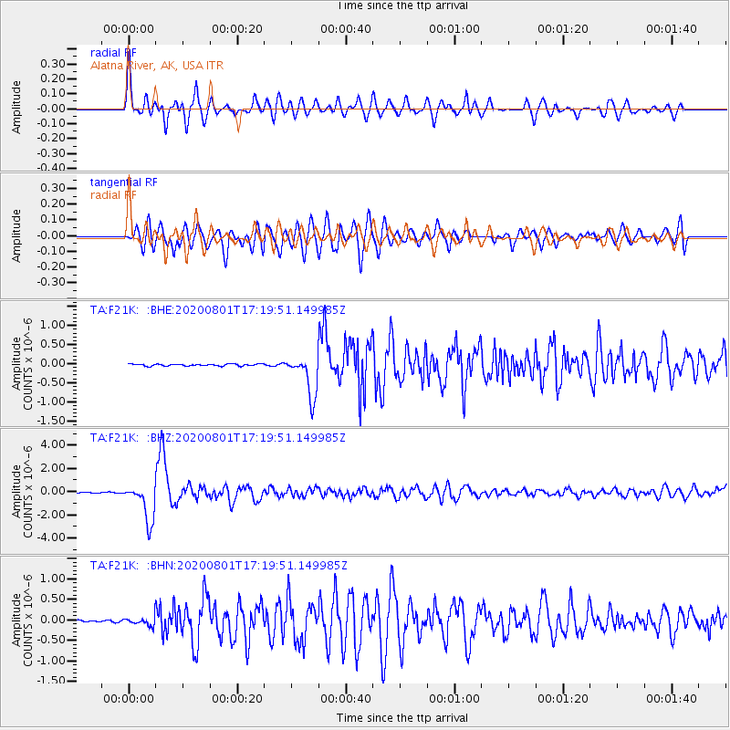
| Radial Match: |
82.33647 % |
| Radial Bump: |
400 |
| Transverse Match: |
77.735596 % |
| Transverse Bump: |
400 |
| SOD ConfigId: |
21709731 |
| Insert Time: |
2020-08-15 17:22:21.962 +0000 |
| GWidth: |
2.5 |
| Max Bumps: |
400 |
| Tol: |
0.001 |
|
Signal To Noise
| Channel | StoN | STA | LTA |
| TA:F21K: :BHZ:20200801T17:19:51.149985Z | 30.722101 | 1.6508922E-6 | 5.3736304E-8 |
| TA:F21K: :BHN:20200801T17:19:51.149985Z | 2.7302191 | 9.356108E-8 | 3.4268705E-8 |
| TA:F21K: :BHE:20200801T17:19:51.149985Z | 21.96775 | 5.5090163E-7 | 2.5077744E-8 |
| Arrivals |
| Ps | 9.9 SECOND |
| PpPs | 28 SECOND |
| PsPs/PpSs | 38 SECOND |


