You are here: Home > Network List > TA - USArray Transportable Network (new EarthScope stations) Stations List
> Station F26K Sheenjek River, AK, USA > Earthquake Result Viewer
F26K Sheenjek River, AK, USA - Earthquake Result Viewer
| Earthquake location: |
Mindanao, Philippines |
| Earthquake latitude/longitude: |
7.3/124.1 |
| Earthquake time(UTC): |
2020/08/01 (214) 17:09:01 GMT |
| Earthquake Depth: |
480 km |
| Earthquake Magnitude: |
6.4 mww |
| Earthquake Catalog/Contributor: |
NEIC PDE/us |
|
| Network: |
TA USArray Transportable Network (new EarthScope stations) |
| Station: |
F26K Sheenjek River, AK, USA |
| Lat/Lon: |
67.69 N/144.15 W |
| Elevation: |
683 m |
|
| Distance: |
83.9 deg |
| Az: |
22.563 deg |
| Baz: |
274.361 deg |
| Ray Param: |
0.04448529 |
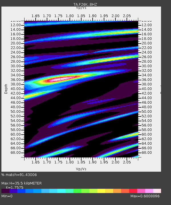
| Estimated Moho Depth: |
35.5 km |
| Estimated Crust Vp/Vs: |
1.76 |
| Assumed Crust Vp: |
6.522 km/s |
| Estimated Crust Vs: |
3.711 km/s |
| Estimated Crust Poisson's Ratio: |
0.26 |
|
| Radial Match: |
91.43006 % |
| Radial Bump: |
304 |
| Transverse Match: |
81.460724 % |
| Transverse Bump: |
400 |
| SOD ConfigId: |
21709731 |
| Insert Time: |
2020-08-15 17:22:27.461 +0000 |
| GWidth: |
2.5 |
| Max Bumps: |
400 |
| Tol: |
0.001 |
|
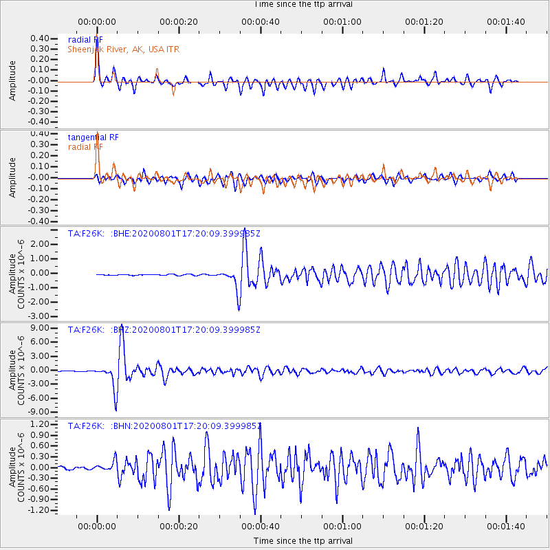
Signal To Noise
| Channel | StoN | STA | LTA |
| TA:F26K: :BHZ:20200801T17:20:09.399985Z | 60.604336 | 2.7276349E-6 | 4.5007255E-8 |
| TA:F26K: :BHN:20200801T17:20:09.399985Z | 6.1458426 | 1.4706492E-7 | 2.3929172E-8 |
| TA:F26K: :BHE:20200801T17:20:09.399985Z | 20.267057 | 7.633273E-7 | 3.766345E-8 |
| Arrivals |
| Ps | 4.2 SECOND |
| PpPs | 15 SECOND |
| PsPs/PpSs | 19 SECOND |


