You are here: Home > Network List > TA - USArray Transportable Network (new EarthScope stations) Stations List
> Station G19K Purcell Mountains, AK, USA > Earthquake Result Viewer
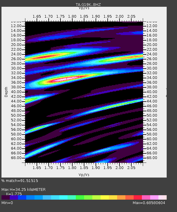
G19K Purcell Mountains, AK, USA - Earthquake Result Viewer
| Earthquake location: |
Mindanao, Philippines |
| Earthquake latitude/longitude: |
7.3/124.1 |
| Earthquake time(UTC): |
2020/08/01 (214) 17:09:01 GMT |
| Earthquake Depth: |
480 km |
| Earthquake Magnitude: |
6.4 mww |
| Earthquake Catalog/Contributor: |
NEIC PDE/us |
|
| Network: |
TA USArray Transportable Network (new EarthScope stations) |
| Station: |
G19K Purcell Mountains, AK, USA |
| Lat/Lon: |
66.14 N/157.09 W |
| Elevation: |
391 m |
|
| Distance: |
78.8 deg |
| Az: |
23.995 deg |
| Baz: |
262.673 deg |
| Ray Param: |
0.04797843 |
| Estimated Moho Depth: |
34.25 km |
| Estimated Crust Vp/Vs: |
1.77 |
| Assumed Crust Vp: |
6.577 km/s |
| Estimated Crust Vs: |
3.705 km/s |
| Estimated Crust Poisson's Ratio: |
0.27 |
|
| Radial Match: |
91.51515 % |
| Radial Bump: |
335 |
| Transverse Match: |
88.72847 % |
| Transverse Bump: |
400 |
| SOD ConfigId: |
21709731 |
| Insert Time: |
2020-08-15 17:22:38.602 +0000 |
| GWidth: |
2.5 |
| Max Bumps: |
400 |
| Tol: |
0.001 |
|

Signal To Noise
| Channel | StoN | STA | LTA |
| TA:G19K: :BHZ:20200801T17:19:43.074973Z | 53.390484 | 2.6349805E-6 | 4.9352998E-8 |
| TA:G19K: :BHN:20200801T17:19:43.074973Z | 6.6860185 | 1.876658E-7 | 2.8068394E-8 |
| TA:G19K: :BHE:20200801T17:19:43.074973Z | 44.60518 | 1.3337774E-6 | 2.9901848E-8 |
| Arrivals |
| Ps | 4.2 SECOND |
| PpPs | 14 SECOND |
| PsPs/PpSs | 18 SECOND |


