You are here: Home > Network List > XN00 - RPI-UW Parkfield Calibration Array Stations List
> Station MRED XN.MRED > Earthquake Result Viewer
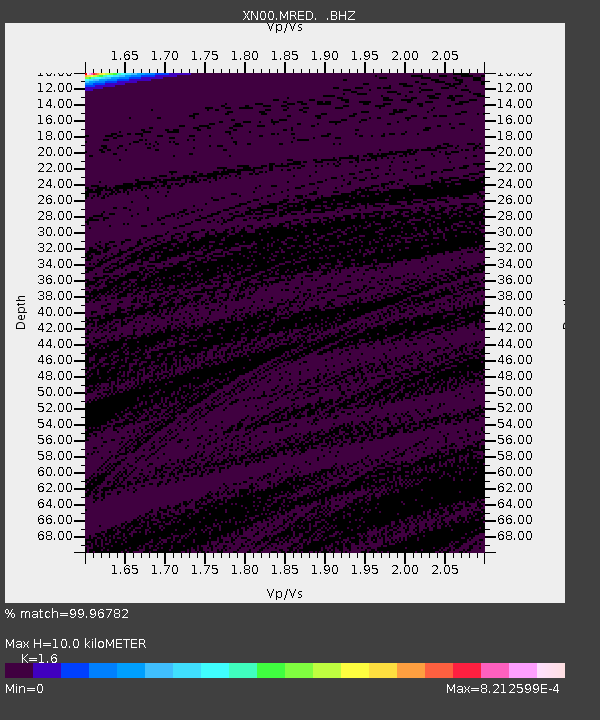
MRED XN.MRED - Earthquake Result Viewer
| Earthquake location: |
Fiji Islands Region |
| Earthquake latitude/longitude: |
-20.3/-176.0 |
| Earthquake time(UTC): |
2002/09/07 (250) 08:14:19 GMT |
| Earthquake Depth: |
210 km |
| Earthquake Magnitude: |
5.5 MB, 6.0 MW, 6.0 MW |
| Earthquake Catalog/Contributor: |
WHDF/NEIC |
|
| Network: |
XN RPI-UW Parkfield Calibration Array |
| Station: |
MRED XN.MRED |
| Lat/Lon: |
35.96 N/120.48 W |
| Elevation: |
608 m |
|
| Distance: |
76.7 deg |
| Az: |
43.419 deg |
| Baz: |
232.691 deg |
| Ray Param: |
0.050248526 |
| Estimated Moho Depth: |
10.0 km |
| Estimated Crust Vp/Vs: |
1.60 |
| Assumed Crust Vp: |
6.183 km/s |
| Estimated Crust Vs: |
3.864 km/s |
| Estimated Crust Poisson's Ratio: |
0.18 |
|
| Radial Match: |
99.96782 % |
| Radial Bump: |
7 |
| Transverse Match: |
99.94983 % |
| Transverse Bump: |
9 |
| SOD ConfigId: |
16820 |
| Insert Time: |
2010-03-08 23:22:28.604 +0000 |
| GWidth: |
2.5 |
| Max Bumps: |
400 |
| Tol: |
0.001 |
|

Signal To Noise
| Channel | StoN | STA | LTA |
| XN:MRED: :BHZ:20020907T08:25:16.600012Z | 0.5040854 | 3.9165667E-7 | 7.769649E-7 |
| XN:MRED: :BHN:20020907T08:25:16.600012Z | 0.6256533 | 2.1864325E-7 | 3.494639E-7 |
| XN:MRED: :BHE:20020907T08:25:16.600012Z | 0.5014068 | 3.890118E-7 | 7.7584076E-7 |
| Arrivals |
| Ps | 1.0 SECOND |
| PpPs | 4.1 SECOND |
| PsPs/PpSs | 5.1 SECOND |


