You are here: Home > Network List > XN00 - RPI-UW Parkfield Calibration Array Stations List
> Station MRED XN.MRED > Earthquake Result Viewer
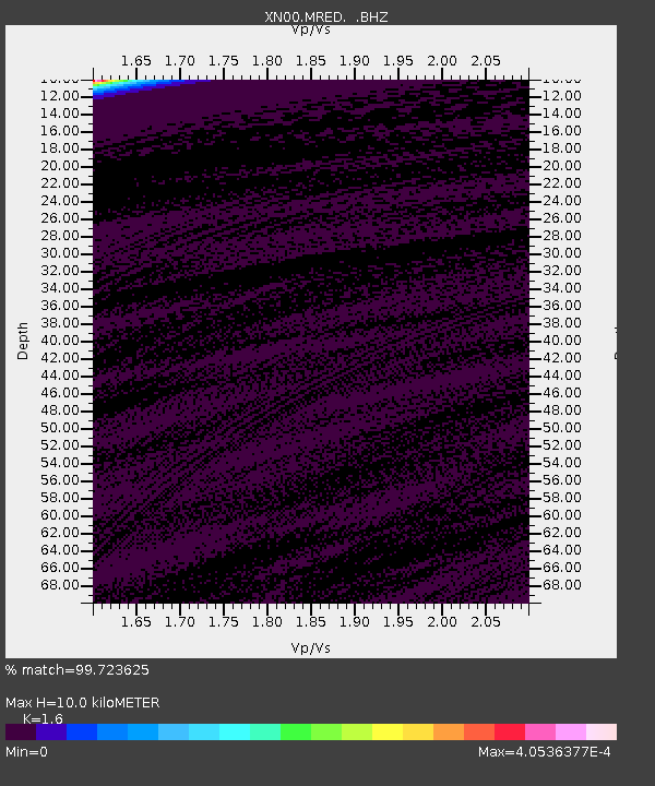
MRED XN.MRED - Earthquake Result Viewer
| Earthquake location: |
Near N Coast Of New Guinea, P.N.G. |
| Earthquake latitude/longitude: |
-3.1/143.1 |
| Earthquake time(UTC): |
2002/09/01 (244) 21:28:04 GMT |
| Earthquake Depth: |
33 km |
| Earthquake Magnitude: |
5.5 MW, 5.1 MS, 5.4 MB |
| Earthquake Catalog/Contributor: |
WHDF/NEIC |
|
| Network: |
XN RPI-UW Parkfield Calibration Array |
| Station: |
MRED XN.MRED |
| Lat/Lon: |
35.96 N/120.48 W |
| Elevation: |
608 m |
|
| Distance: |
97.0 deg |
| Az: |
54.32 deg |
| Baz: |
271.214 deg |
| Ray Param: |
0.040320203 |
| Estimated Moho Depth: |
10.0 km |
| Estimated Crust Vp/Vs: |
1.60 |
| Assumed Crust Vp: |
6.183 km/s |
| Estimated Crust Vs: |
3.864 km/s |
| Estimated Crust Poisson's Ratio: |
0.18 |
|
| Radial Match: |
99.723625 % |
| Radial Bump: |
25 |
| Transverse Match: |
99.99997 % |
| Transverse Bump: |
2 |
| SOD ConfigId: |
16820 |
| Insert Time: |
2010-03-08 23:22:31.492 +0000 |
| GWidth: |
2.5 |
| Max Bumps: |
400 |
| Tol: |
0.001 |
|

Signal To Noise
| Channel | StoN | STA | LTA |
| XN:MRED: :BHZ:20020901T21:41:01.499014Z | 0.49926576 | 5.339987E-7 | 1.069568E-6 |
| XN:MRED: :BHN:20020901T21:41:01.499014Z | 0.8036054 | 2.6016633E-7 | 3.2374888E-7 |
| XN:MRED: :BHE:20020901T21:41:01.499014Z | 0.49860993 | 5.336673E-7 | 1.0703102E-6 |
| Arrivals |
| Ps | 1.0 SECOND |
| PpPs | 4.1 SECOND |
| PsPs/PpSs | 5.1 SECOND |


