You are here: Home > Network List > TA - USArray Transportable Network (new EarthScope stations) Stations List
> Station K15K Wolf Creek Mountain, AK, USA > Earthquake Result Viewer
K15K Wolf Creek Mountain, AK, USA - Earthquake Result Viewer
| Earthquake location: |
Mindanao, Philippines |
| Earthquake latitude/longitude: |
7.3/124.1 |
| Earthquake time(UTC): |
2020/08/01 (214) 17:09:01 GMT |
| Earthquake Depth: |
480 km |
| Earthquake Magnitude: |
6.4 mww |
| Earthquake Catalog/Contributor: |
NEIC PDE/us |
|
| Network: |
TA USArray Transportable Network (new EarthScope stations) |
| Station: |
K15K Wolf Creek Mountain, AK, USA |
| Lat/Lon: |
62.29 N/161.53 W |
| Elevation: |
346 m |
|
| Distance: |
76.3 deg |
| Az: |
27.594 deg |
| Baz: |
259.45 deg |
| Ray Param: |
0.049639355 |
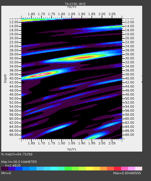
| Estimated Moho Depth: |
38.0 km |
| Estimated Crust Vp/Vs: |
1.69 |
| Assumed Crust Vp: |
6.276 km/s |
| Estimated Crust Vs: |
3.708 km/s |
| Estimated Crust Poisson's Ratio: |
0.23 |
|
| Radial Match: |
84.75358 % |
| Radial Bump: |
322 |
| Transverse Match: |
91.189186 % |
| Transverse Bump: |
383 |
| SOD ConfigId: |
21709731 |
| Insert Time: |
2020-08-15 17:23:19.655 +0000 |
| GWidth: |
2.5 |
| Max Bumps: |
400 |
| Tol: |
0.001 |
|
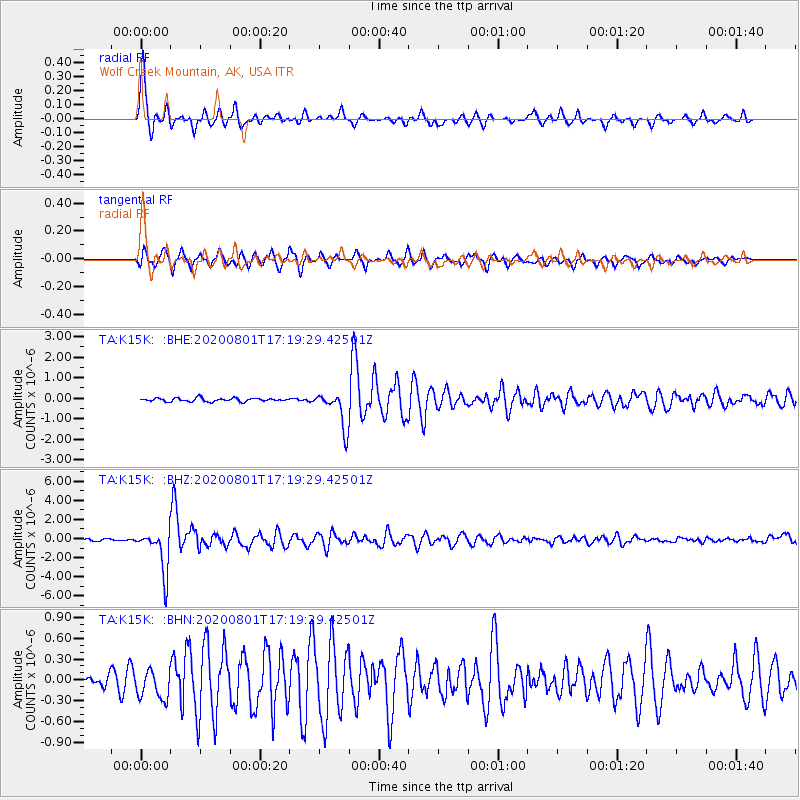
Signal To Noise
| Channel | StoN | STA | LTA |
| TA:K15K: :BHZ:20200801T17:19:29.42501Z | 15.5678215 | 2.244516E-6 | 1.4417664E-7 |
| TA:K15K: :BHN:20200801T17:19:29.42501Z | 2.9227204 | 2.1451564E-7 | 7.339588E-8 |
| TA:K15K: :BHE:20200801T17:19:29.42501Z | 10.798766 | 8.834247E-7 | 8.1807926E-8 |
| Arrivals |
| Ps | 4.3 SECOND |
| PpPs | 16 SECOND |
| PsPs/PpSs | 20 SECOND |


