You are here: Home > Network List > TA - USArray Transportable Network (new EarthScope stations) Stations List
> Station L14K Kuka Creek, AK, USA > Earthquake Result Viewer
L14K Kuka Creek, AK, USA - Earthquake Result Viewer
| Earthquake location: |
Mindanao, Philippines |
| Earthquake latitude/longitude: |
7.3/124.1 |
| Earthquake time(UTC): |
2020/08/01 (214) 17:09:01 GMT |
| Earthquake Depth: |
480 km |
| Earthquake Magnitude: |
6.4 mww |
| Earthquake Catalog/Contributor: |
NEIC PDE/us |
|
| Network: |
TA USArray Transportable Network (new EarthScope stations) |
| Station: |
L14K Kuka Creek, AK, USA |
| Lat/Lon: |
61.34 N/162.68 W |
| Elevation: |
41 m |
|
| Distance: |
75.6 deg |
| Az: |
28.454 deg |
| Baz: |
258.645 deg |
| Ray Param: |
0.05011871 |
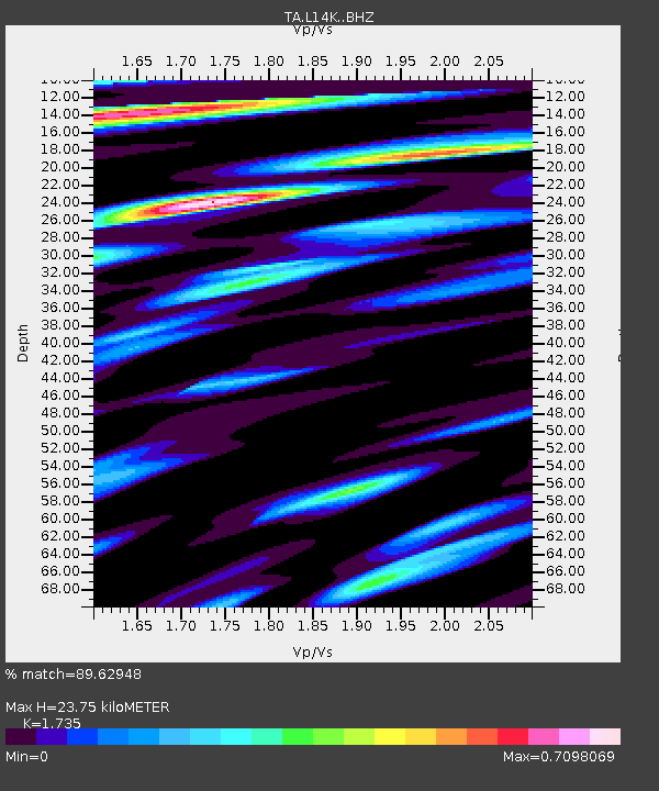
| Estimated Moho Depth: |
23.75 km |
| Estimated Crust Vp/Vs: |
1.74 |
| Assumed Crust Vp: |
6.1 km/s |
| Estimated Crust Vs: |
3.516 km/s |
| Estimated Crust Poisson's Ratio: |
0.25 |
|
| Radial Match: |
89.62948 % |
| Radial Bump: |
400 |
| Transverse Match: |
92.22851 % |
| Transverse Bump: |
400 |
| SOD ConfigId: |
21709731 |
| Insert Time: |
2020-08-15 17:23:23.833 +0000 |
| GWidth: |
2.5 |
| Max Bumps: |
400 |
| Tol: |
0.001 |
|

Signal To Noise
| Channel | StoN | STA | LTA |
| TA:L14K: :BHZ:20200801T17:19:25.449973Z | 31.29773 | 2.7267129E-6 | 8.7121755E-8 |
| TA:L14K: :BHN:20200801T17:19:25.449973Z | 4.8299313 | 3.0987965E-7 | 6.415819E-8 |
| TA:L14K: :BHE:20200801T17:19:25.449973Z | 10.262154 | 8.1658465E-7 | 7.957244E-8 |
| Arrivals |
| Ps | 2.9 SECOND |
| PpPs | 10 SECOND |
| PsPs/PpSs | 13 SECOND |


