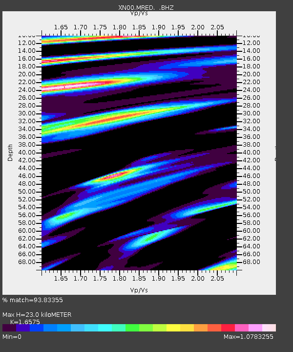
MRED XN.MRED - Earthquake Result Viewer

Earthquake location: South Of Alaska
Earthquake latitude/longitude: 53.8/-161.1
Earthquake time(UTC): 2002/05/25 (145) 05:36:31 GMT
Earthquake Depth: 33 km
Earthquake Magnitude: 5.5 MB, 6.1 MS, 6.5 MW, 6.4 MW
Earthquake Catalog/Contributor: WHDF/NEIC
Network: XN RPI-UW Parkfield Calibration Array
Station: MRED XN.MRED
Lat/Lon: 35.96 N/120.48 W
Elevation: 608 m
Distance: 33.3 deg
Az: 105.754 deg
Baz: 315.293 deg
Ray Param: 0.07822122
Estimated Moho Depth: 23.0 km
Estimated Crust Vp/Vs: 1.66
Assumed Crust Vp: 6.183 km/s
Estimated Crust Vs: 3.73 km/s
Estimated Crust Poisson's Ratio: 0.21
Radial Match: 93.83355 %
Radial Bump: 369
Transverse Match: 95.869896 %
Transverse Bump: 365
SOD ConfigId: 16844
Insert Time: 2010-03-08 23:22:44.040 +0000
GWidth: 2.5
Max Bumps: 400
Tol: 0.001

Signal To Noise

ChannelStoNSTALTA
XN:MRED: :BHZ:20020525T05:42:36.148986Z1.76990024.1502224E-72.3448906E-7
XN:MRED: :BHN:20020525T05:42:36.148986Z1.33106663.2628913E-72.4513358E-7
XN:MRED: :BHE:20020525T05:42:36.148986Z2.19471454.96264E-72.2611778E-7
Arrivals
Ps2.6 SECOND
PpPs9.2 SECOND
PsPs/PpSs12 SECOND