You are here: Home > Network List > UW - Pacific Northwest Regional Seismic Network Stations List
> Station HOOD Mt Hood Meadows, OR CREST BB SMO > Earthquake Result Viewer
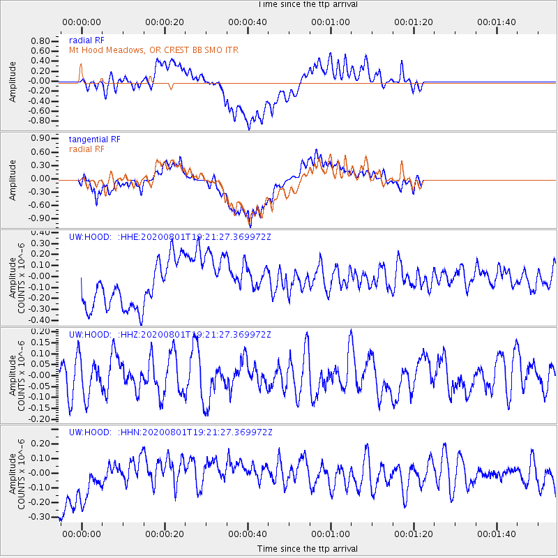
HOOD Mt Hood Meadows, OR CREST BB SMO - Earthquake Result Viewer
*The percent match for this event was below the threshold and hence no stack was calculated.
| Earthquake location: |
Bismarck Sea |
| Earthquake latitude/longitude: |
-3.2/148.7 |
| Earthquake time(UTC): |
2020/08/01 (214) 19:08:50 GMT |
| Earthquake Depth: |
10 km |
| Earthquake Magnitude: |
5.7 Mww |
| Earthquake Catalog/Contributor: |
NEIC PDE/us |
|
| Network: |
UW Pacific Northwest Regional Seismic Network |
| Station: |
HOOD Mt Hood Meadows, OR CREST BB SMO |
| Lat/Lon: |
45.32 N/121.65 W |
| Elevation: |
1520 m |
|
| Distance: |
92.0 deg |
| Az: |
44.903 deg |
| Baz: |
267.503 deg |
| Ray Param: |
$rayparam |
*The percent match for this event was below the threshold and hence was not used in the summary stack. |
|
| Radial Match: |
55.756115 % |
| Radial Bump: |
400 |
| Transverse Match: |
61.087322 % |
| Transverse Bump: |
400 |
| SOD ConfigId: |
21709731 |
| Insert Time: |
2020-08-15 19:20:23.831 +0000 |
| GWidth: |
2.5 |
| Max Bumps: |
400 |
| Tol: |
0.001 |
|
Signal To Noise
| Channel | StoN | STA | LTA |
| UW:HOOD: :HHZ:20200801T19:21:27.369972Z | 1.6228766 | 8.723589E-8 | 5.3753862E-8 |
| UW:HOOD: :HHN:20200801T19:21:27.369972Z | 0.7286627 | 1.6647624E-7 | 2.2846818E-7 |
| UW:HOOD: :HHE:20200801T19:21:27.369972Z | 1.4055597 | 2.7806593E-7 | 1.9783289E-7 |
| Arrivals |
| Ps | |
| PpPs | |
| PsPs/PpSs | |


