You are here: Home > Network List > AV - Alaska Volcano Observatory Stations List
> Station PLBL Mt. Peulik Volcano, Alaska > Earthquake Result Viewer
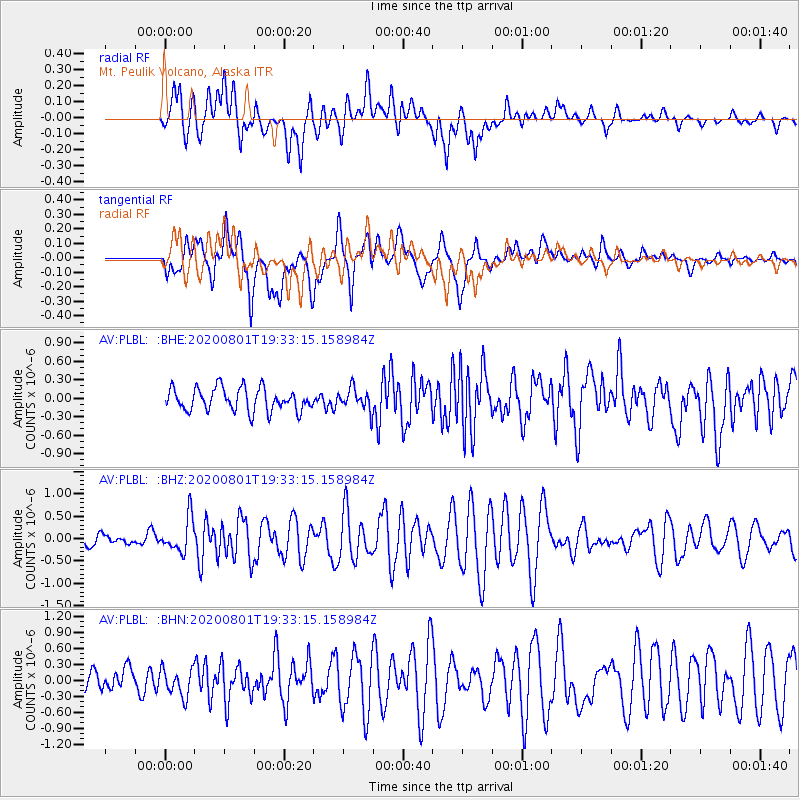
PLBL Mt. Peulik Volcano, Alaska - Earthquake Result Viewer
*The percent match for this event was below the threshold and hence no stack was calculated.
| Earthquake location: |
Bismarck Sea |
| Earthquake latitude/longitude: |
-3.2/148.6 |
| Earthquake time(UTC): |
2020/08/01 (214) 19:22:06 GMT |
| Earthquake Depth: |
10 km |
| Earthquake Magnitude: |
5.7 Mww |
| Earthquake Catalog/Contributor: |
NEIC PDE/us |
|
| Network: |
AV Alaska Volcano Observatory |
| Station: |
PLBL Mt. Peulik Volcano, Alaska |
| Lat/Lon: |
57.70 N/156.82 W |
| Elevation: |
461 m |
|
| Distance: |
74.7 deg |
| Az: |
26.967 deg |
| Baz: |
237.486 deg |
| Ray Param: |
$rayparam |
*The percent match for this event was below the threshold and hence was not used in the summary stack. |
|
| Radial Match: |
65.4876 % |
| Radial Bump: |
400 |
| Transverse Match: |
59.74329 % |
| Transverse Bump: |
400 |
| SOD ConfigId: |
21709731 |
| Insert Time: |
2020-08-15 19:26:04.785 +0000 |
| GWidth: |
2.5 |
| Max Bumps: |
400 |
| Tol: |
0.001 |
|
Signal To Noise
| Channel | StoN | STA | LTA |
| AV:PLBL: :BHZ:20200801T19:33:15.158984Z | 2.6229894 | 3.7853013E-7 | 1.443125E-7 |
| AV:PLBL: :BHN:20200801T19:33:15.158984Z | 1.252931 | 2.698469E-7 | 2.1537251E-7 |
| AV:PLBL: :BHE:20200801T19:33:15.158984Z | 0.9825985 | 1.8120907E-7 | 1.8441824E-7 |
| Arrivals |
| Ps | |
| PpPs | |
| PsPs/PpSs | |


