You are here: Home > Network List > CU - Caribbean Network (USGS) Stations List
> Station MTDJ Mount Denham, Jamaica > Earthquake Result Viewer
MTDJ Mount Denham, Jamaica - Earthquake Result Viewer
| Earthquake location: |
Komandorskiye Ostrova Region |
| Earthquake latitude/longitude: |
54.2/169.2 |
| Earthquake time(UTC): |
2017/07/17 (198) 23:34:21 GMT |
| Earthquake Depth: |
48 km |
| Earthquake Magnitude: |
7.4 Mi |
| Earthquake Catalog/Contributor: |
NEIC PDE/pt |
|
| Network: |
CU Caribbean Network (USGS) |
| Station: |
MTDJ Mount Denham, Jamaica |
| Lat/Lon: |
18.23 N/77.53 W |
| Elevation: |
925 m |
|
| Distance: |
88.2 deg |
| Az: |
60.878 deg |
| Baz: |
327.315 deg |
| Ray Param: |
0.04266603 |
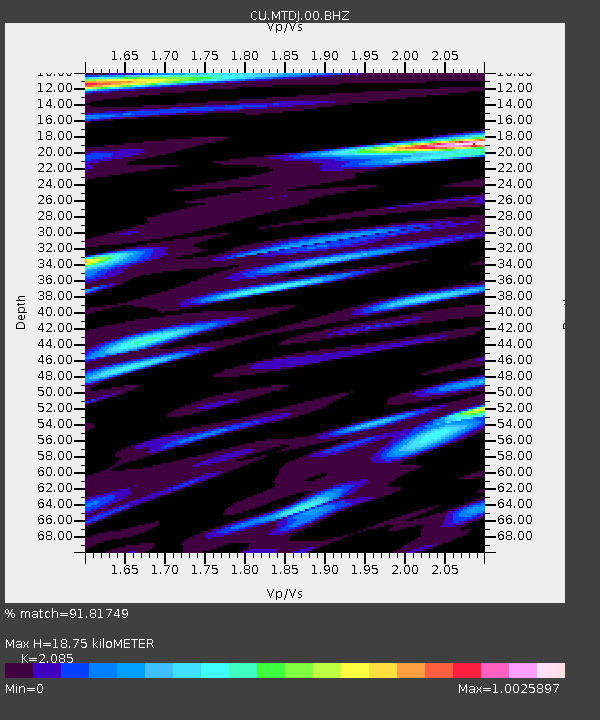
| Estimated Moho Depth: |
18.75 km |
| Estimated Crust Vp/Vs: |
2.09 |
| Assumed Crust Vp: |
4.662 km/s |
| Estimated Crust Vs: |
2.236 km/s |
| Estimated Crust Poisson's Ratio: |
0.35 |
|
| Radial Match: |
91.81749 % |
| Radial Bump: |
400 |
| Transverse Match: |
79.869995 % |
| Transverse Bump: |
400 |
| SOD ConfigId: |
2140511 |
| Insert Time: |
2017-07-31 15:32:25.029 +0000 |
| GWidth: |
2.5 |
| Max Bumps: |
400 |
| Tol: |
0.001 |
|

Signal To Noise
| Channel | StoN | STA | LTA |
| CU:MTDJ:00:BHZ:20170717T23:46:35.799011Z | 3.1914334 | 6.07646E-7 | 1.9039906E-7 |
| CU:MTDJ:00:BH1:20170717T23:46:35.799011Z | 1.495904 | 4.6494128E-7 | 3.1080958E-7 |
| CU:MTDJ:00:BH2:20170717T23:46:35.799011Z | 0.92977554 | 2.4196657E-7 | 2.602419E-7 |
| Arrivals |
| Ps | 4.4 SECOND |
| PpPs | 12 SECOND |
| PsPs/PpSs | 17 SECOND |


