You are here: Home > Network List > TA - USArray Transportable Network (new EarthScope stations) Stations List
> Station C27K Jago River, AK, USA > Earthquake Result Viewer
C27K Jago River, AK, USA - Earthquake Result Viewer
| Earthquake location: |
Bismarck Sea |
| Earthquake latitude/longitude: |
-3.2/148.6 |
| Earthquake time(UTC): |
2020/08/01 (214) 19:22:06 GMT |
| Earthquake Depth: |
10 km |
| Earthquake Magnitude: |
5.7 Mww |
| Earthquake Catalog/Contributor: |
NEIC PDE/us |
|
| Network: |
TA USArray Transportable Network (new EarthScope stations) |
| Station: |
C27K Jago River, AK, USA |
| Lat/Lon: |
69.63 N/143.71 W |
| Elevation: |
392 m |
|
| Distance: |
85.4 deg |
| Az: |
18.965 deg |
| Baz: |
247.901 deg |
| Ray Param: |
0.04480813 |
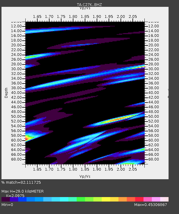
| Estimated Moho Depth: |
29.0 km |
| Estimated Crust Vp/Vs: |
2.10 |
| Assumed Crust Vp: |
6.522 km/s |
| Estimated Crust Vs: |
3.109 km/s |
| Estimated Crust Poisson's Ratio: |
0.35 |
|
| Radial Match: |
82.111725 % |
| Radial Bump: |
400 |
| Transverse Match: |
78.376076 % |
| Transverse Bump: |
400 |
| SOD ConfigId: |
21709731 |
| Insert Time: |
2020-08-15 19:33:30.745 +0000 |
| GWidth: |
2.5 |
| Max Bumps: |
400 |
| Tol: |
0.001 |
|

Signal To Noise
| Channel | StoN | STA | LTA |
| TA:C27K: :BHZ:20200801T19:34:12.600024Z | 2.2959788 | 1.8428145E-7 | 8.0262694E-8 |
| TA:C27K: :BHN:20200801T19:34:12.600024Z | 0.760368 | 5.985854E-8 | 7.8723126E-8 |
| TA:C27K: :BHE:20200801T19:34:12.600024Z | 0.93469954 | 9.131578E-8 | 9.769533E-8 |
| Arrivals |
| Ps | 5.0 SECOND |
| PpPs | 13 SECOND |
| PsPs/PpSs | 18 SECOND |


