You are here: Home > Network List > XN00 - RPI-UW Parkfield Calibration Array Stations List
> Station PIGH XN.PIGH > Earthquake Result Viewer
PIGH XN.PIGH - Earthquake Result Viewer
| Earthquake location: |
Chile-Bolivia Border Region |
| Earthquake latitude/longitude: |
-21.7/-68.3 |
| Earthquake time(UTC): |
2002/03/28 (087) 04:56:22 GMT |
| Earthquake Depth: |
125 km |
| Earthquake Magnitude: |
6.1 MB, 6.5 MW, 6.5 MW |
| Earthquake Catalog/Contributor: |
WHDF/NEIC |
|
| Network: |
XN RPI-UW Parkfield Calibration Array |
| Station: |
PIGH XN.PIGH |
| Lat/Lon: |
35.96 N/120.57 W |
| Elevation: |
718 m |
|
| Distance: |
75.7 deg |
| Az: |
318.551 deg |
| Baz: |
130.623 deg |
| Ray Param: |
0.05120825 |
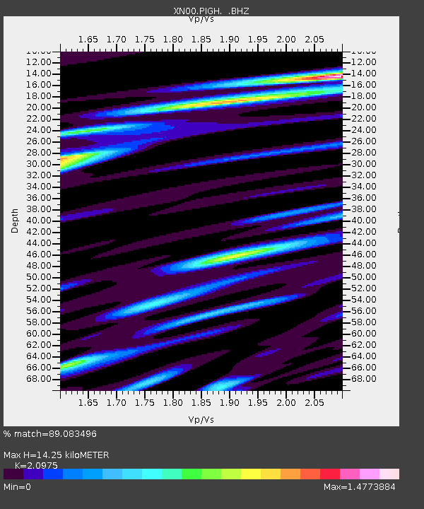
| Estimated Moho Depth: |
14.25 km |
| Estimated Crust Vp/Vs: |
2.10 |
| Assumed Crust Vp: |
6.183 km/s |
| Estimated Crust Vs: |
2.948 km/s |
| Estimated Crust Poisson's Ratio: |
0.35 |
|
| Radial Match: |
89.083496 % |
| Radial Bump: |
400 |
| Transverse Match: |
83.40872 % |
| Transverse Bump: |
400 |
| SOD ConfigId: |
16820 |
| Insert Time: |
2010-03-08 23:24:04.023 +0000 |
| GWidth: |
2.5 |
| Max Bumps: |
400 |
| Tol: |
0.001 |
|

Signal To Noise
| Channel | StoN | STA | LTA |
| XN:PIGH: :BHZ:20020328T05:07:22.949011Z | 2.5436056 | 1.9147587E-6 | 7.527734E-7 |
| XN:PIGH: :BHN:20020328T05:07:22.949011Z | 1.6187373 | 1.3400177E-6 | 8.278166E-7 |
| XN:PIGH: :BHE:20020328T05:07:22.949011Z | 9.165994 | 5.832802E-6 | 6.3635235E-7 |
| Arrivals |
| Ps | 2.6 SECOND |
| PpPs | 7.0 SECOND |
| PsPs/PpSs | 9.6 SECOND |


