You are here: Home > Network List > G - GEOSCOPE Stations List
> Station NOUC Port Laguerre, New Caledonia > Earthquake Result Viewer
NOUC Port Laguerre, New Caledonia - Earthquake Result Viewer

| Earthquake location: |
Komandorskiye Ostrova Region |
| Earthquake latitude/longitude: |
54.2/169.2 |
| Earthquake time(UTC): |
2017/07/17 (198) 23:34:21 GMT |
| Earthquake Depth: |
48 km |
| Earthquake Magnitude: |
7.4 Mi |
| Earthquake Catalog/Contributor: |
NEIC PDE/pt |
|
| Network: |
G GEOSCOPE |
| Station: |
NOUC Port Laguerre, New Caledonia |
| Lat/Lon: |
22.10 S/166.30 E |
| Elevation: |
112 m |
|
| Distance: |
76.0 deg |
| Az: |
182.769 deg |
| Baz: |
1.754 deg |
| Ray Param: |
0.051183544 |
| Estimated Moho Depth: |
24.75 km |
| Estimated Crust Vp/Vs: |
1.60 |
| Assumed Crust Vp: |
5.14 km/s |
| Estimated Crust Vs: |
3.212 km/s |
| Estimated Crust Poisson's Ratio: |
0.18 |
|
| Radial Match: |
96.26396 % |
| Radial Bump: |
366 |
| Transverse Match: |
91.31288 % |
| Transverse Bump: |
400 |
| SOD ConfigId: |
2140511 |
| Insert Time: |
2017-07-31 15:33:13.102 +0000 |
| GWidth: |
2.5 |
| Max Bumps: |
400 |
| Tol: |
0.001 |
|
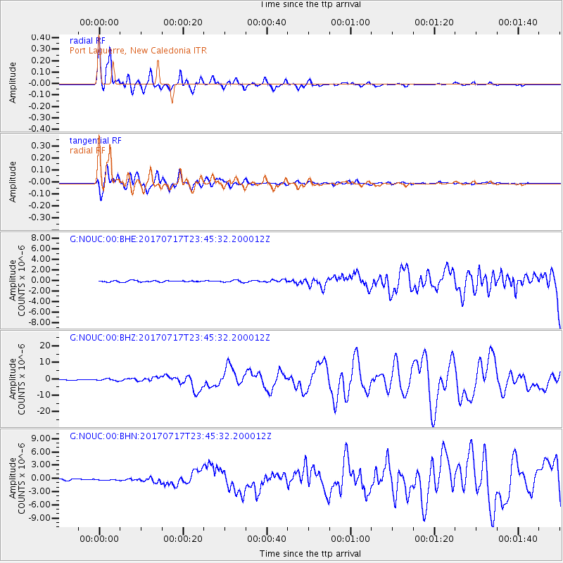
Signal To Noise
| Channel | StoN | STA | LTA |
| G:NOUC:00:BHZ:20170717T23:45:32.200012Z | 3.7734299 | 5.8005526E-7 | 1.5372096E-7 |
| G:NOUC:00:BHN:20170717T23:45:32.200012Z | 0.71585304 | 1.1103783E-7 | 1.5511259E-7 |
| G:NOUC:00:BHE:20170717T23:45:32.200012Z | 1.4902035 | 1.9526232E-7 | 1.3103065E-7 |
| Arrivals |
| Ps | 3.0 SECOND |
| PpPs | 12 SECOND |
| PsPs/PpSs | 15 SECOND |


