You are here: Home > Network List > GS - US Geological Survey Networks Stations List
> Station DEC06 Boomer > Earthquake Result Viewer
DEC06 Boomer - Earthquake Result Viewer
| Earthquake location: |
Komandorskiye Ostrova Region |
| Earthquake latitude/longitude: |
54.2/169.2 |
| Earthquake time(UTC): |
2017/07/17 (198) 23:34:21 GMT |
| Earthquake Depth: |
48 km |
| Earthquake Magnitude: |
7.4 Mi |
| Earthquake Catalog/Contributor: |
NEIC PDE/pt |
|
| Network: |
GS US Geological Survey Networks |
| Station: |
DEC06 Boomer |
| Lat/Lon: |
39.90 N/88.95 W |
| Elevation: |
215 m |
|
| Distance: |
64.9 deg |
| Az: |
56.242 deg |
| Baz: |
320.584 deg |
| Ray Param: |
0.058521233 |
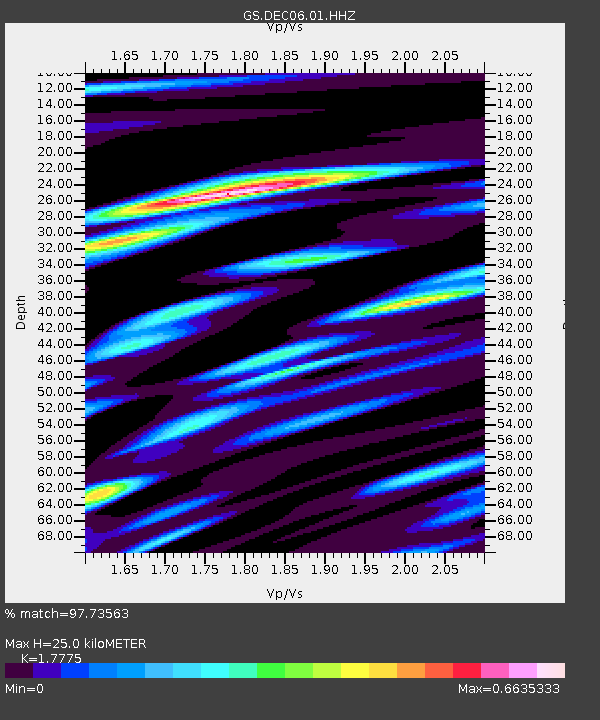
| Estimated Moho Depth: |
25.0 km |
| Estimated Crust Vp/Vs: |
1.78 |
| Assumed Crust Vp: |
6.444 km/s |
| Estimated Crust Vs: |
3.625 km/s |
| Estimated Crust Poisson's Ratio: |
0.27 |
|
| Radial Match: |
97.73563 % |
| Radial Bump: |
309 |
| Transverse Match: |
89.55589 % |
| Transverse Bump: |
400 |
| SOD ConfigId: |
2140511 |
| Insert Time: |
2017-07-31 15:33:30.200 +0000 |
| GWidth: |
2.5 |
| Max Bumps: |
400 |
| Tol: |
0.001 |
|

Signal To Noise
| Channel | StoN | STA | LTA |
| GS:DEC06:01:HHZ:20170717T23:44:24.604004Z | 5.1020427 | 1.0173302E-6 | 1.9939664E-7 |
| GS:DEC06:01:HHN:20170717T23:44:24.604004Z | 1.5876384 | 5.7524636E-7 | 3.623283E-7 |
| GS:DEC06:01:HHE:20170717T23:44:24.604004Z | 1.8241714 | 5.2289073E-7 | 2.866456E-7 |
| Arrivals |
| Ps | 3.1 SECOND |
| PpPs | 10 SECOND |
| PsPs/PpSs | 13 SECOND |


