You are here: Home > Network List > GS - US Geological Survey Networks Stations List
> Station KAN06 West of Argonia, Argonia, KS, USA > Earthquake Result Viewer
KAN06 West of Argonia, Argonia, KS, USA - Earthquake Result Viewer
| Earthquake location: |
Komandorskiye Ostrova Region |
| Earthquake latitude/longitude: |
54.2/169.2 |
| Earthquake time(UTC): |
2017/07/17 (198) 23:34:21 GMT |
| Earthquake Depth: |
48 km |
| Earthquake Magnitude: |
7.4 Mi |
| Earthquake Catalog/Contributor: |
NEIC PDE/pt |
|
| Network: |
GS US Geological Survey Networks |
| Station: |
KAN06 West of Argonia, Argonia, KS, USA |
| Lat/Lon: |
37.25 N/97.86 W |
| Elevation: |
393 m |
|
| Distance: |
62.4 deg |
| Az: |
64.084 deg |
| Baz: |
318.529 deg |
| Ray Param: |
0.060160752 |
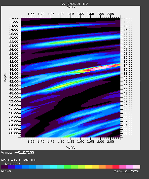
| Estimated Moho Depth: |
35.0 km |
| Estimated Crust Vp/Vs: |
2.00 |
| Assumed Crust Vp: |
6.483 km/s |
| Estimated Crust Vs: |
3.245 km/s |
| Estimated Crust Poisson's Ratio: |
0.33 |
|
| Radial Match: |
91.217155 % |
| Radial Bump: |
400 |
| Transverse Match: |
59.049297 % |
| Transverse Bump: |
400 |
| SOD ConfigId: |
2140511 |
| Insert Time: |
2017-07-31 15:33:49.597 +0000 |
| GWidth: |
2.5 |
| Max Bumps: |
400 |
| Tol: |
0.001 |
|

Signal To Noise
| Channel | StoN | STA | LTA |
| GS:KAN06:01:HHZ:20170717T23:44:07.984985Z | 2.7492323 | 6.888028E-7 | 2.5054368E-7 |
| GS:KAN06:01:HHN:20170717T23:44:07.984985Z | 1.1511099 | 6.343987E-7 | 5.511191E-7 |
| GS:KAN06:01:HHE:20170717T23:44:07.984985Z | 2.592714 | 3.1408292E-6 | 1.2114059E-6 |
| Arrivals |
| Ps | 5.6 SECOND |
| PpPs | 16 SECOND |
| PsPs/PpSs | 21 SECOND |


