You are here: Home > Network List > TA - USArray Transportable Network (new EarthScope stations) Stations List
> Station I17K Unalakleet, AK, USA > Earthquake Result Viewer
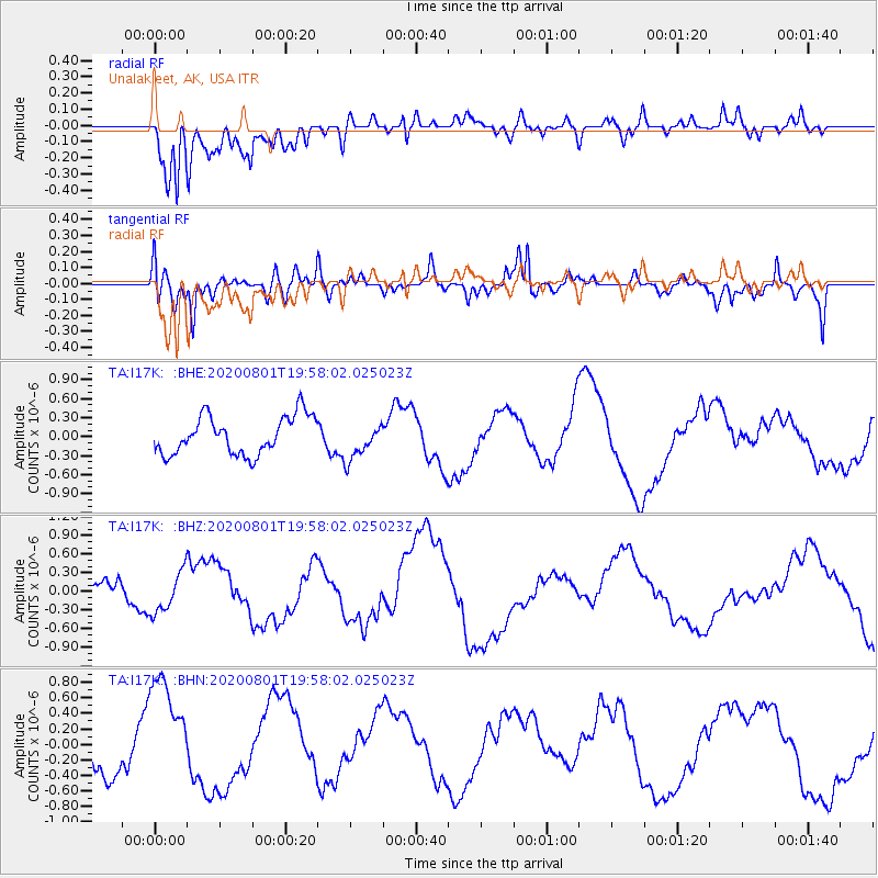
I17K Unalakleet, AK, USA - Earthquake Result Viewer
*The percent match for this event was below the threshold and hence no stack was calculated.
| Earthquake location: |
Tonga Islands Region |
| Earthquake latitude/longitude: |
-23.1/-175.8 |
| Earthquake time(UTC): |
2020/08/01 (214) 19:45:45 GMT |
| Earthquake Depth: |
10 km |
| Earthquake Magnitude: |
5.6 Mww |
| Earthquake Catalog/Contributor: |
NEIC PDE/us |
|
| Network: |
TA USArray Transportable Network (new EarthScope stations) |
| Station: |
I17K Unalakleet, AK, USA |
| Lat/Lon: |
63.89 N/160.70 W |
| Elevation: |
105 m |
|
| Distance: |
87.5 deg |
| Az: |
6.636 deg |
| Baz: |
193.917 deg |
| Ray Param: |
$rayparam |
*The percent match for this event was below the threshold and hence was not used in the summary stack. |
|
| Radial Match: |
82.90173 % |
| Radial Bump: |
400 |
| Transverse Match: |
60.930645 % |
| Transverse Bump: |
400 |
| SOD ConfigId: |
21709731 |
| Insert Time: |
2020-08-15 19:58:40.065 +0000 |
| GWidth: |
2.5 |
| Max Bumps: |
400 |
| Tol: |
0.001 |
|
Signal To Noise
| Channel | StoN | STA | LTA |
| TA:I17K: :BHZ:20200801T19:58:02.025023Z | 1.5620985 | 3.3151102E-7 | 2.122216E-7 |
| TA:I17K: :BHN:20200801T19:58:02.025023Z | 2.346067 | 6.849008E-7 | 2.9193572E-7 |
| TA:I17K: :BHE:20200801T19:58:02.025023Z | 0.95482576 | 2.8725506E-7 | 3.0084553E-7 |
| Arrivals |
| Ps | |
| PpPs | |
| PsPs/PpSs | |


