You are here: Home > Network List > TA - USArray Transportable Network (new EarthScope stations) Stations List
> Station M31M Drury Creek, Yukon, CA > Earthquake Result Viewer
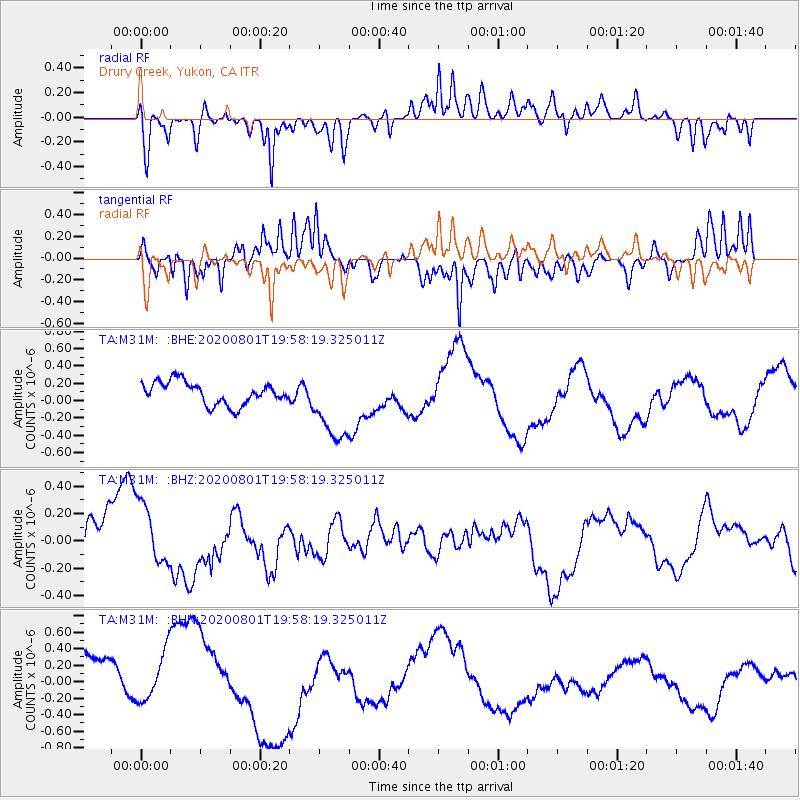
M31M Drury Creek, Yukon, CA - Earthquake Result Viewer
*The percent match for this event was below the threshold and hence no stack was calculated.
| Earthquake location: |
Tonga Islands Region |
| Earthquake latitude/longitude: |
-23.1/-175.8 |
| Earthquake time(UTC): |
2020/08/01 (214) 19:45:45 GMT |
| Earthquake Depth: |
10 km |
| Earthquake Magnitude: |
5.6 Mww |
| Earthquake Catalog/Contributor: |
NEIC PDE/us |
|
| Network: |
TA USArray Transportable Network (new EarthScope stations) |
| Station: |
M31M Drury Creek, Yukon, CA |
| Lat/Lon: |
62.20 N/134.39 W |
| Elevation: |
639 m |
|
| Distance: |
91.2 deg |
| Az: |
18.075 deg |
| Baz: |
217.555 deg |
| Ray Param: |
$rayparam |
*The percent match for this event was below the threshold and hence was not used in the summary stack. |
|
| Radial Match: |
49.115726 % |
| Radial Bump: |
400 |
| Transverse Match: |
65.35004 % |
| Transverse Bump: |
400 |
| SOD ConfigId: |
21709731 |
| Insert Time: |
2020-08-15 19:58:56.360 +0000 |
| GWidth: |
2.5 |
| Max Bumps: |
400 |
| Tol: |
0.001 |
|
Signal To Noise
| Channel | StoN | STA | LTA |
| TA:M31M: :BHZ:20200801T19:58:19.325011Z | 1.197913 | 2.361331E-7 | 1.971204E-7 |
| TA:M31M: :BHN:20200801T19:58:19.325011Z | 0.90446806 | 3.599602E-7 | 3.9798002E-7 |
| TA:M31M: :BHE:20200801T19:58:19.325011Z | 3.2448585 | 4.2271654E-7 | 1.3027272E-7 |
| Arrivals |
| Ps | |
| PpPs | |
| PsPs/PpSs | |


