You are here: Home > Network List > GS - US Geological Survey Networks Stations List
> Station MT01 Lincoln Ranger Stn, Helena Natl Forest, Montana, USA > Earthquake Result Viewer
MT01 Lincoln Ranger Stn, Helena Natl Forest, Montana, USA - Earthquake Result Viewer

| Earthquake location: |
Komandorskiye Ostrova Region |
| Earthquake latitude/longitude: |
54.2/169.2 |
| Earthquake time(UTC): |
2017/07/17 (198) 23:34:21 GMT |
| Earthquake Depth: |
48 km |
| Earthquake Magnitude: |
7.4 Mi |
| Earthquake Catalog/Contributor: |
NEIC PDE/pt |
|
| Network: |
GS US Geological Survey Networks |
| Station: |
MT01 Lincoln Ranger Stn, Helena Natl Forest, Montana, USA |
| Lat/Lon: |
46.95 N/112.66 W |
| Elevation: |
1318 m |
|
| Distance: |
47.8 deg |
| Az: |
64.894 deg |
| Baz: |
309.046 deg |
| Ray Param: |
0.06966425 |
| Estimated Moho Depth: |
40.25 km |
| Estimated Crust Vp/Vs: |
1.70 |
| Assumed Crust Vp: |
6.353 km/s |
| Estimated Crust Vs: |
3.743 km/s |
| Estimated Crust Poisson's Ratio: |
0.23 |
|
| Radial Match: |
92.14902 % |
| Radial Bump: |
400 |
| Transverse Match: |
87.08131 % |
| Transverse Bump: |
400 |
| SOD ConfigId: |
2140511 |
| Insert Time: |
2017-07-31 15:34:50.919 +0000 |
| GWidth: |
2.5 |
| Max Bumps: |
400 |
| Tol: |
0.001 |
|
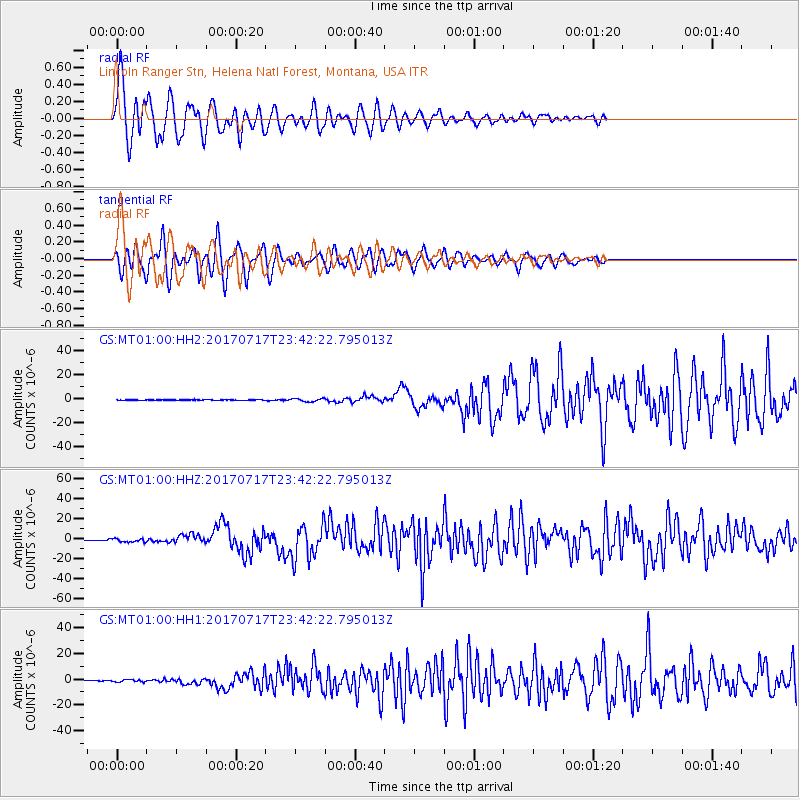
Signal To Noise
| Channel | StoN | STA | LTA |
| GS:MT01:00:HHZ:20170717T23:42:22.795013Z | 9.31629 | 1.7761167E-6 | 1.9064635E-7 |
| GS:MT01:00:HH1:20170717T23:42:22.795013Z | 3.898614 | 9.1563555E-7 | 2.3486182E-7 |
| GS:MT01:00:HH2:20170717T23:42:22.795013Z | 5.2527285 | 1.271521E-6 | 2.4206867E-7 |
| Arrivals |
| Ps | 4.7 SECOND |
| PpPs | 16 SECOND |
| PsPs/PpSs | 21 SECOND |


