You are here: Home > Network List > GS - US Geological Survey Networks Stations List
> Station MT03 Stemple Pass Rd, Helena Natl Forest, Montana, USA > Earthquake Result Viewer
MT03 Stemple Pass Rd, Helena Natl Forest, Montana, USA - Earthquake Result Viewer
| Earthquake location: |
Komandorskiye Ostrova Region |
| Earthquake latitude/longitude: |
54.2/169.2 |
| Earthquake time(UTC): |
2017/07/17 (198) 23:34:21 GMT |
| Earthquake Depth: |
48 km |
| Earthquake Magnitude: |
7.4 Mi |
| Earthquake Catalog/Contributor: |
NEIC PDE/pt |
|
| Network: |
GS US Geological Survey Networks |
| Station: |
MT03 Stemple Pass Rd, Helena Natl Forest, Montana, USA |
| Lat/Lon: |
46.91 N/112.50 W |
| Elevation: |
2025 m |
|
| Distance: |
47.9 deg |
| Az: |
64.844 deg |
| Baz: |
309.127 deg |
| Ray Param: |
0.06959625 |
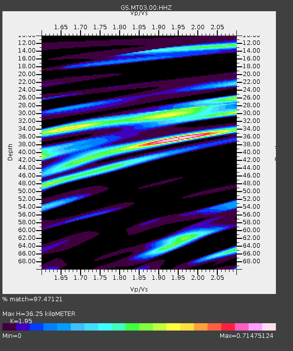
| Estimated Moho Depth: |
36.25 km |
| Estimated Crust Vp/Vs: |
1.95 |
| Assumed Crust Vp: |
6.353 km/s |
| Estimated Crust Vs: |
3.258 km/s |
| Estimated Crust Poisson's Ratio: |
0.32 |
|
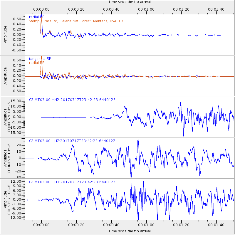
| Radial Match: |
97.47121 % |
| Radial Bump: |
400 |
| Transverse Match: |
87.67018 % |
| Transverse Bump: |
400 |
| SOD ConfigId: |
2140511 |
| Insert Time: |
2017-07-31 15:34:58.909 +0000 |
| GWidth: |
2.5 |
| Max Bumps: |
400 |
| Tol: |
0.001 |
|
Signal To Noise
| Channel | StoN | STA | LTA |
| GS:MT03:00:HHZ:20170717T23:42:23.644012Z | 7.416641 | 1.3938726E-6 | 1.8793853E-7 |
| GS:MT03:00:HH1:20170717T23:42:23.644012Z | 4.341501 | 4.7684966E-7 | 1.098352E-7 |
| GS:MT03:00:HH2:20170717T23:42:23.644012Z | 5.9562244 | 6.200462E-7 | 1.04100536E-7 |
| Arrivals |
| Ps | 5.7 SECOND |
| PpPs | 16 SECOND |
| PsPs/PpSs | 22 SECOND |


