You are here: Home > Network List > IU - Global Seismograph Network (GSN - IRIS/USGS) Stations List
> Station COR Corvallis, Oregon, USA > Earthquake Result Viewer
COR Corvallis, Oregon, USA - Earthquake Result Viewer
| Earthquake location: |
Komandorskiye Ostrova Region |
| Earthquake latitude/longitude: |
54.2/169.2 |
| Earthquake time(UTC): |
2017/07/17 (198) 23:34:21 GMT |
| Earthquake Depth: |
48 km |
| Earthquake Magnitude: |
7.4 Mi |
| Earthquake Catalog/Contributor: |
NEIC PDE/pt |
|
| Network: |
IU Global Seismograph Network (GSN - IRIS/USGS) |
| Station: |
COR Corvallis, Oregon, USA |
| Lat/Lon: |
44.59 N/123.30 W |
| Elevation: |
110 m |
|
| Distance: |
43.4 deg |
| Az: |
73.966 deg |
| Baz: |
307.79 deg |
| Ray Param: |
0.07245827 |
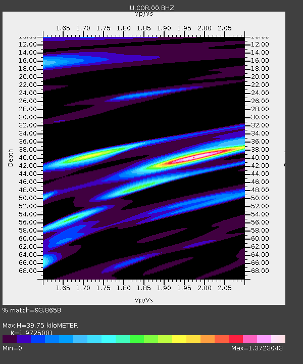
| Estimated Moho Depth: |
39.75 km |
| Estimated Crust Vp/Vs: |
1.97 |
| Assumed Crust Vp: |
6.566 km/s |
| Estimated Crust Vs: |
3.329 km/s |
| Estimated Crust Poisson's Ratio: |
0.33 |
|
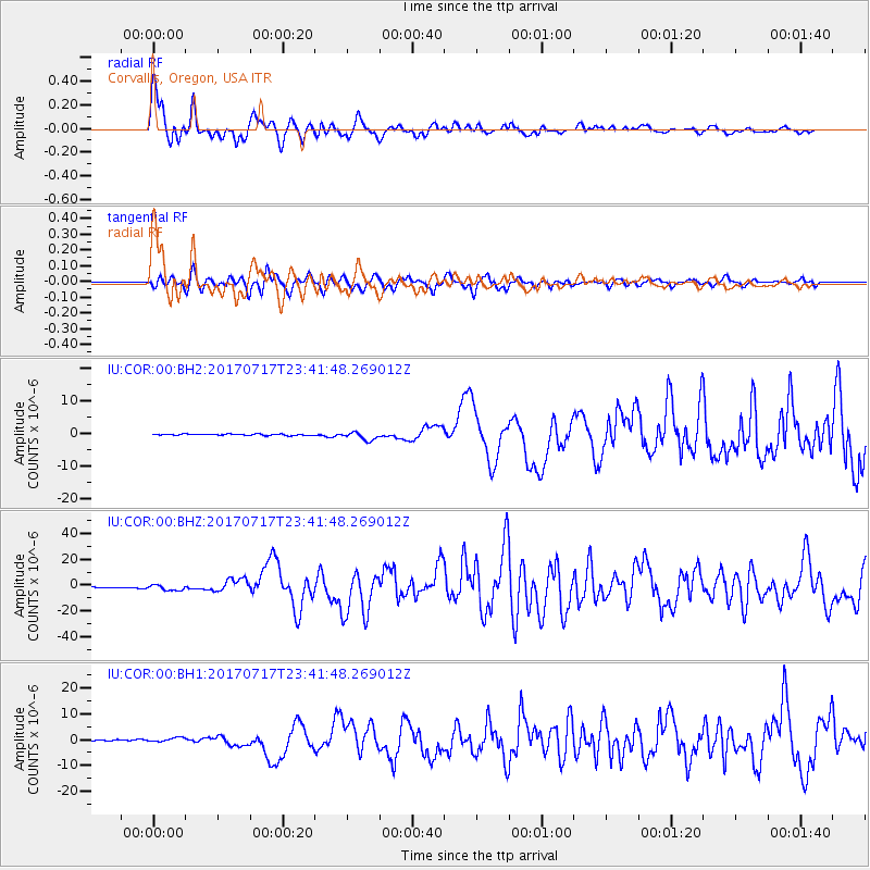
| Radial Match: |
93.8658 % |
| Radial Bump: |
400 |
| Transverse Match: |
87.13595 % |
| Transverse Bump: |
400 |
| SOD ConfigId: |
2140511 |
| Insert Time: |
2017-07-31 15:35:49.649 +0000 |
| GWidth: |
2.5 |
| Max Bumps: |
400 |
| Tol: |
0.001 |
|
Signal To Noise
| Channel | StoN | STA | LTA |
| IU:COR:00:BHZ:20170717T23:41:48.269012Z | 6.728366 | 2.195815E-6 | 3.2635188E-7 |
| IU:COR:00:BH1:20170717T23:41:48.269012Z | 3.8316088 | 8.4842014E-7 | 2.214266E-7 |
| IU:COR:00:BH2:20170717T23:41:48.269012Z | 5.621371 | 1.2179677E-6 | 2.1666739E-7 |
| Arrivals |
| Ps | 6.3 SECOND |
| PpPs | 17 SECOND |
| PsPs/PpSs | 23 SECOND |


