You are here: Home > Network List > IU - Global Seismograph Network (GSN - IRIS/USGS) Stations List
> Station JOHN Johnston Island, USA > Earthquake Result Viewer
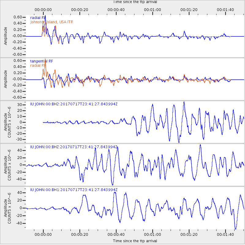
JOHN Johnston Island, USA - Earthquake Result Viewer
*The percent match for this event was below the threshold and hence no stack was calculated.
| Earthquake location: |
Komandorskiye Ostrova Region |
| Earthquake latitude/longitude: |
54.2/169.2 |
| Earthquake time(UTC): |
2017/07/17 (198) 23:34:21 GMT |
| Earthquake Depth: |
48 km |
| Earthquake Magnitude: |
7.4 Mi |
| Earthquake Catalog/Contributor: |
NEIC PDE/pt |
|
| Network: |
IU Global Seismograph Network (GSN - IRIS/USGS) |
| Station: |
JOHN Johnston Island, USA |
| Lat/Lon: |
16.73 N/169.53 W |
| Elevation: |
2.0 m |
|
| Distance: |
40.9 deg |
| Az: |
147.913 deg |
| Baz: |
340.991 deg |
| Ray Param: |
$rayparam |
*The percent match for this event was below the threshold and hence was not used in the summary stack. |
|
| Radial Match: |
93.31678 % |
| Radial Bump: |
385 |
| Transverse Match: |
81.02598 % |
| Transverse Bump: |
379 |
| SOD ConfigId: |
2140511 |
| Insert Time: |
2017-07-31 15:36:00.636 +0000 |
| GWidth: |
2.5 |
| Max Bumps: |
400 |
| Tol: |
0.001 |
|
Signal To Noise
| Channel | StoN | STA | LTA |
| IU:JOHN:00:BHZ:20170717T23:41:27.843994Z | 3.307358 | 3.243226E-6 | 9.806093E-7 |
| IU:JOHN:00:BH1:20170717T23:41:27.843994Z | 1.4925835 | 1.9288743E-6 | 1.2923058E-6 |
| IU:JOHN:00:BH2:20170717T23:41:27.843994Z | 1.0286864 | 1.2366114E-6 | 1.2021268E-6 |
| Arrivals |
| Ps | |
| PpPs | |
| PsPs/PpSs | |


