You are here: Home > Network List > IU - Global Seismograph Network (GSN - IRIS/USGS) Stations List
> Station ULN Ulaanbaatar, Mongolia > Earthquake Result Viewer
ULN Ulaanbaatar, Mongolia - Earthquake Result Viewer
| Earthquake location: |
Komandorskiye Ostrova Region |
| Earthquake latitude/longitude: |
54.2/169.2 |
| Earthquake time(UTC): |
2017/07/17 (198) 23:34:21 GMT |
| Earthquake Depth: |
48 km |
| Earthquake Magnitude: |
7.4 Mi |
| Earthquake Catalog/Contributor: |
NEIC PDE/pt |
|
| Network: |
IU Global Seismograph Network (GSN - IRIS/USGS) |
| Station: |
ULN Ulaanbaatar, Mongolia |
| Lat/Lon: |
47.87 N/107.05 E |
| Elevation: |
1610 m |
|
| Distance: |
38.5 deg |
| Az: |
286.806 deg |
| Baz: |
56.646 deg |
| Ray Param: |
0.0754285 |
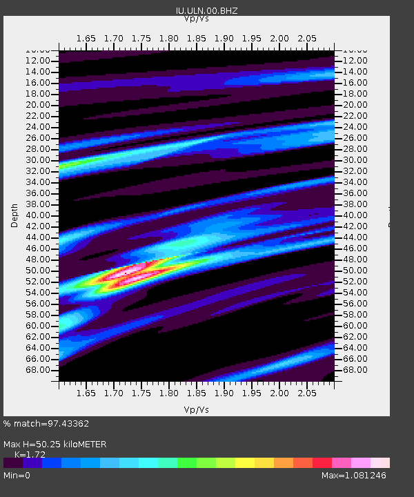
| Estimated Moho Depth: |
50.25 km |
| Estimated Crust Vp/Vs: |
1.72 |
| Assumed Crust Vp: |
6.642 km/s |
| Estimated Crust Vs: |
3.862 km/s |
| Estimated Crust Poisson's Ratio: |
0.24 |
|
| Radial Match: |
97.43362 % |
| Radial Bump: |
272 |
| Transverse Match: |
82.87506 % |
| Transverse Bump: |
400 |
| SOD ConfigId: |
2140511 |
| Insert Time: |
2017-07-31 15:36:37.687 +0000 |
| GWidth: |
2.5 |
| Max Bumps: |
400 |
| Tol: |
0.001 |
|
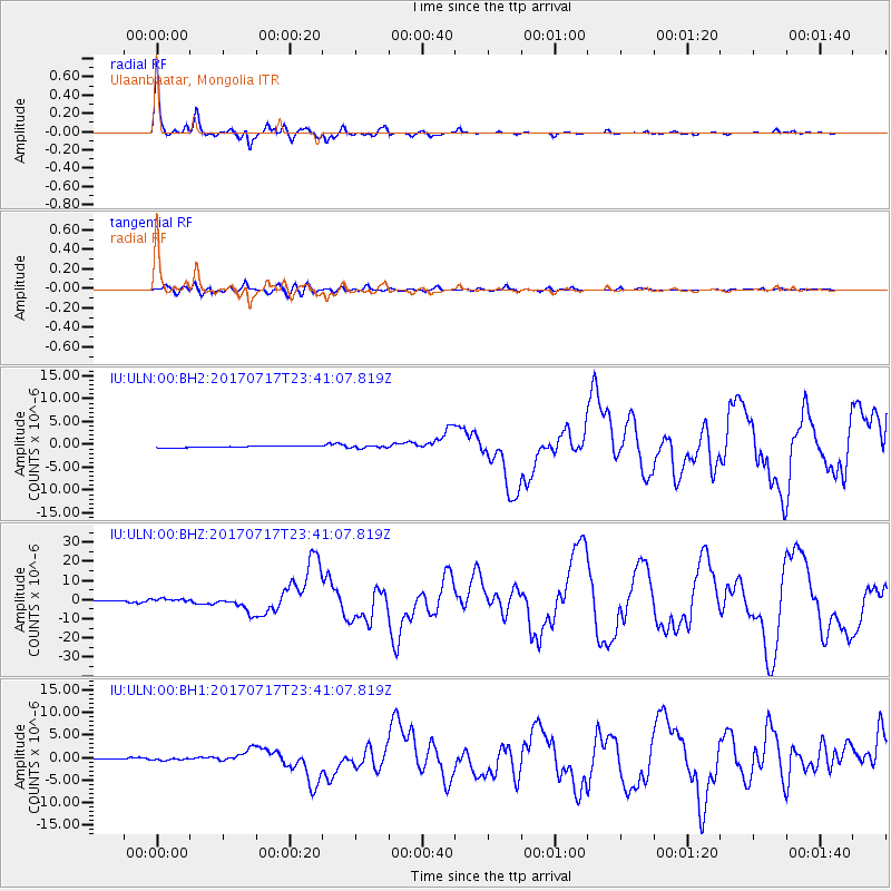
Signal To Noise
| Channel | StoN | STA | LTA |
| IU:ULN:00:BHZ:20170717T23:41:07.819Z | 3.2280533 | 6.4646514E-7 | 2.0026471E-7 |
| IU:ULN:00:BH1:20170717T23:41:07.819Z | 2.0000167 | 2.0012988E-7 | 1.000641E-7 |
| IU:ULN:00:BH2:20170717T23:41:07.819Z | 1.451041 | 2.353736E-7 | 1.6221018E-7 |
| Arrivals |
| Ps | 5.9 SECOND |
| PpPs | 19 SECOND |
| PsPs/PpSs | 25 SECOND |


