You are here: Home > Network List > XC00 - Yellowstone Intermountain Seismic Array Stations List
> Station Y103 Y103 > Earthquake Result Viewer
Y103 Y103 - Earthquake Result Viewer
| Earthquake location: |
Bonin Islands, Japan Region |
| Earthquake latitude/longitude: |
26.3/140.5 |
| Earthquake time(UTC): |
2000/10/27 (301) 04:21:51 GMT |
| Earthquake Depth: |
388 km |
| Earthquake Magnitude: |
6.1 MB, 6.1 MW, 6.0 MW |
| Earthquake Catalog/Contributor: |
WHDF/NEIC |
|
| Network: |
XC Yellowstone Intermountain Seismic Array |
| Station: |
Y103 Y103 |
| Lat/Lon: |
44.58 N/110.81 W |
| Elevation: |
2213 m |
|
| Distance: |
84.2 deg |
| Az: |
42.87 deg |
| Baz: |
301.263 deg |
| Ray Param: |
0.044645313 |
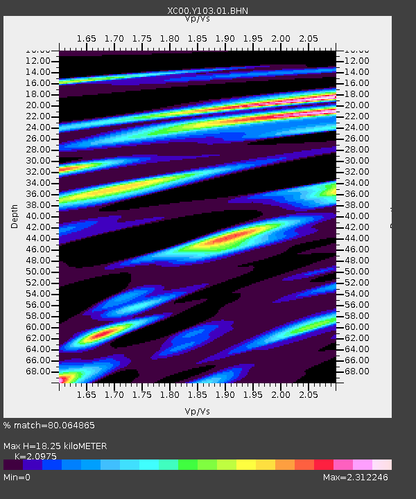
| Estimated Moho Depth: |
18.25 km |
| Estimated Crust Vp/Vs: |
2.10 |
| Assumed Crust Vp: |
6.35 km/s |
| Estimated Crust Vs: |
3.027 km/s |
| Estimated Crust Poisson's Ratio: |
0.35 |
|
| Radial Match: |
80.064865 % |
| Radial Bump: |
400 |
| Transverse Match: |
70.50569 % |
| Transverse Bump: |
400 |
| SOD ConfigId: |
16820 |
| Insert Time: |
2010-02-26 15:00:17.594 +0000 |
| GWidth: |
2.5 |
| Max Bumps: |
400 |
| Tol: |
0.001 |
|
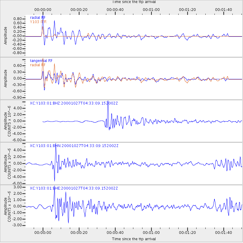
Signal To Noise
| Channel | StoN | STA | LTA |
| XC:Y103:01:BHN:20001027T04:33:09.152002Z | 1.4097955 | 2.8135975E-7 | 1.9957486E-7 |
| XC:Y103:01:BHE:20001027T04:33:09.152002Z | 2.1453266 | 2.3989193E-7 | 1.11820704E-7 |
| XC:Y103:01:BHZ:20001027T04:33:09.152002Z | 4.5209394 | 5.2036023E-7 | 1.1510002E-7 |
| Arrivals |
| Ps | 3.2 SECOND |
| PpPs | 8.7 SECOND |
| PsPs/PpSs | 12 SECOND |


