You are here: Home > Network List > TA - USArray Transportable Network (new EarthScope stations) Stations List
> Station I17K Unalakleet, AK, USA > Earthquake Result Viewer
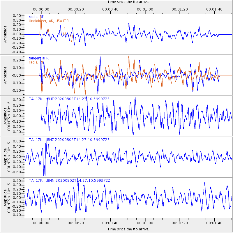
I17K Unalakleet, AK, USA - Earthquake Result Viewer
*The percent match for this event was below the threshold and hence no stack was calculated.
| Earthquake location: |
Eastern New Guinea Reg., P.N.G. |
| Earthquake latitude/longitude: |
-5.1/145.4 |
| Earthquake time(UTC): |
2020/08/02 (215) 14:15:47 GMT |
| Earthquake Depth: |
122 km |
| Earthquake Magnitude: |
5.4 Mww |
| Earthquake Catalog/Contributor: |
NEIC PDE/us |
|
| Network: |
TA USArray Transportable Network (new EarthScope stations) |
| Station: |
I17K Unalakleet, AK, USA |
| Lat/Lon: |
63.89 N/160.70 W |
| Elevation: |
105 m |
|
| Distance: |
79.6 deg |
| Az: |
21.321 deg |
| Baz: |
234.925 deg |
| Ray Param: |
$rayparam |
*The percent match for this event was below the threshold and hence was not used in the summary stack. |
|
| Radial Match: |
56.15122 % |
| Radial Bump: |
400 |
| Transverse Match: |
57.41264 % |
| Transverse Bump: |
400 |
| SOD ConfigId: |
21709731 |
| Insert Time: |
2020-08-16 14:25:44.814 +0000 |
| GWidth: |
2.5 |
| Max Bumps: |
400 |
| Tol: |
0.001 |
|
Signal To Noise
| Channel | StoN | STA | LTA |
| TA:I17K: :BHZ:20200802T14:27:10.599972Z | 2.7221029 | 3.861551E-7 | 1.4185912E-7 |
| TA:I17K: :BHN:20200802T14:27:10.599972Z | 1.2756459 | 1.3237428E-7 | 1.037704E-7 |
| TA:I17K: :BHE:20200802T14:27:10.599972Z | 1.3782766 | 1.6729153E-7 | 1.2137733E-7 |
| Arrivals |
| Ps | |
| PpPs | |
| PsPs/PpSs | |


