You are here: Home > Network List > NE - New England Seismic Network Stations List
> Station QUA2 Belchertown, MA, USA > Earthquake Result Viewer
QUA2 Belchertown, MA, USA - Earthquake Result Viewer
| Earthquake location: |
Komandorskiye Ostrova Region |
| Earthquake latitude/longitude: |
54.2/169.2 |
| Earthquake time(UTC): |
2017/07/17 (198) 23:34:21 GMT |
| Earthquake Depth: |
48 km |
| Earthquake Magnitude: |
7.4 Mi |
| Earthquake Catalog/Contributor: |
NEIC PDE/pt |
|
| Network: |
NE New England Seismic Network |
| Station: |
QUA2 Belchertown, MA, USA |
| Lat/Lon: |
42.28 N/72.35 W |
| Elevation: |
168 m |
|
| Distance: |
70.4 deg |
| Az: |
43.824 deg |
| Baz: |
326.756 deg |
| Ray Param: |
0.054882385 |
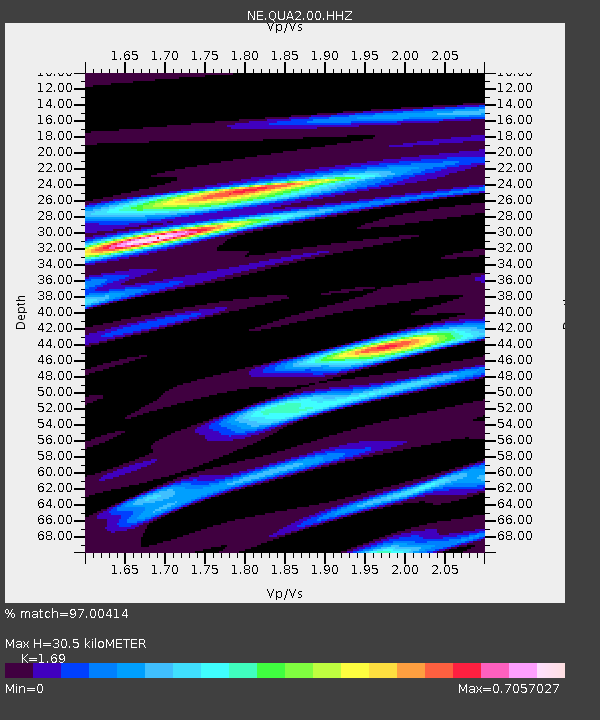
| Estimated Moho Depth: |
30.5 km |
| Estimated Crust Vp/Vs: |
1.69 |
| Assumed Crust Vp: |
6.419 km/s |
| Estimated Crust Vs: |
3.798 km/s |
| Estimated Crust Poisson's Ratio: |
0.23 |
|
| Radial Match: |
97.00414 % |
| Radial Bump: |
297 |
| Transverse Match: |
87.83952 % |
| Transverse Bump: |
400 |
| SOD ConfigId: |
2140511 |
| Insert Time: |
2017-07-31 15:37:41.517 +0000 |
| GWidth: |
2.5 |
| Max Bumps: |
400 |
| Tol: |
0.001 |
|

Signal To Noise
| Channel | StoN | STA | LTA |
| NE:QUA2:00:HHZ:20170717T23:44:59.429016Z | 3.5531464 | 3.1318785E-7 | 8.814381E-8 |
| NE:QUA2:00:HH1:20170717T23:44:59.429016Z | 1.6471304 | 1.16623056E-7 | 7.080378E-8 |
| NE:QUA2:00:HH2:20170717T23:44:59.429016Z | 0.78869253 | 6.9775744E-8 | 8.847015E-8 |
| Arrivals |
| Ps | 3.4 SECOND |
| PpPs | 12 SECOND |
| PsPs/PpSs | 16 SECOND |


