You are here: Home > Network List > NM - Cooperative New Madrid Seismic Network Stations List
> Station HICK Hickman,KY > Earthquake Result Viewer
HICK Hickman,KY - Earthquake Result Viewer
| Earthquake location: |
Komandorskiye Ostrova Region |
| Earthquake latitude/longitude: |
54.2/169.2 |
| Earthquake time(UTC): |
2017/07/17 (198) 23:34:21 GMT |
| Earthquake Depth: |
48 km |
| Earthquake Magnitude: |
7.4 Mi |
| Earthquake Catalog/Contributor: |
NEIC PDE/pt |
|
| Network: |
NM Cooperative New Madrid Seismic Network |
| Station: |
HICK Hickman,KY |
| Lat/Lon: |
36.54 N/89.23 W |
| Elevation: |
141 m |
|
| Distance: |
67.4 deg |
| Az: |
58.736 deg |
| Baz: |
321.419 deg |
| Ray Param: |
0.05690469 |
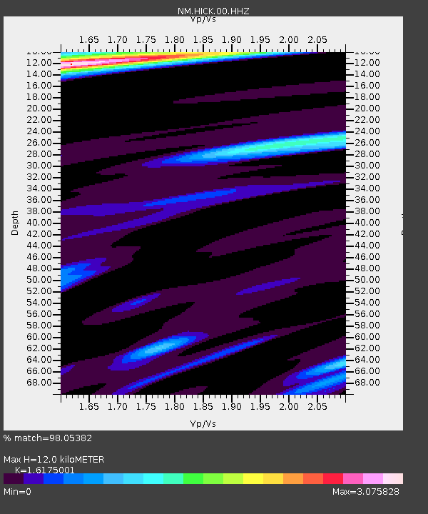
| Estimated Moho Depth: |
12.0 km |
| Estimated Crust Vp/Vs: |
1.62 |
| Assumed Crust Vp: |
6.444 km/s |
| Estimated Crust Vs: |
3.984 km/s |
| Estimated Crust Poisson's Ratio: |
0.19 |
|
| Radial Match: |
98.05382 % |
| Radial Bump: |
344 |
| Transverse Match: |
92.97636 % |
| Transverse Bump: |
400 |
| SOD ConfigId: |
2140511 |
| Insert Time: |
2017-07-31 15:38:09.194 +0000 |
| GWidth: |
2.5 |
| Max Bumps: |
400 |
| Tol: |
0.001 |
|

Signal To Noise
| Channel | StoN | STA | LTA |
| NM:HICK:00:HHZ:20170717T23:44:40.36499Z | 6.853916 | 1.0239797E-6 | 1.4940068E-7 |
| NM:HICK:00:HHN:20170717T23:44:40.36499Z | 2.5915737 | 5.997868E-7 | 2.314373E-7 |
| NM:HICK:00:HHE:20170717T23:44:40.36499Z | 1.9553331 | 4.1231766E-7 | 2.1086825E-7 |
| Arrivals |
| Ps | 1.2 SECOND |
| PpPs | 4.7 SECOND |
| PsPs/PpSs | 5.9 SECOND |


