You are here: Home > Network List > NM - Cooperative New Madrid Seismic Network Stations List
> Station LNXT Lenox,TN > Earthquake Result Viewer
LNXT Lenox,TN - Earthquake Result Viewer
| Earthquake location: |
Komandorskiye Ostrova Region |
| Earthquake latitude/longitude: |
54.2/169.2 |
| Earthquake time(UTC): |
2017/07/17 (198) 23:34:21 GMT |
| Earthquake Depth: |
48 km |
| Earthquake Magnitude: |
7.4 Mi |
| Earthquake Catalog/Contributor: |
NEIC PDE/pt |
|
| Network: |
NM Cooperative New Madrid Seismic Network |
| Station: |
LNXT Lenox,TN |
| Lat/Lon: |
36.10 N/89.49 W |
| Elevation: |
144 m |
|
| Distance: |
67.6 deg |
| Az: |
59.212 deg |
| Baz: |
321.447 deg |
| Ray Param: |
0.056767162 |
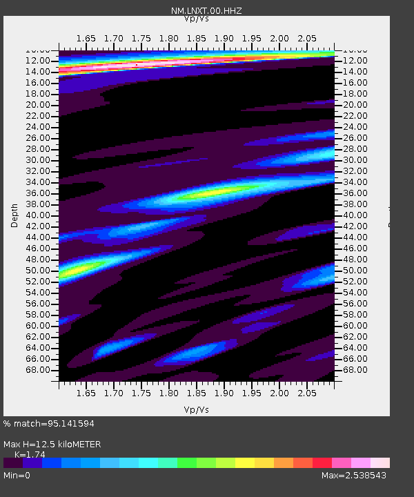
| Estimated Moho Depth: |
12.5 km |
| Estimated Crust Vp/Vs: |
1.74 |
| Assumed Crust Vp: |
6.444 km/s |
| Estimated Crust Vs: |
3.703 km/s |
| Estimated Crust Poisson's Ratio: |
0.25 |
|
| Radial Match: |
95.141594 % |
| Radial Bump: |
299 |
| Transverse Match: |
85.02218 % |
| Transverse Bump: |
400 |
| SOD ConfigId: |
2140511 |
| Insert Time: |
2017-07-31 15:38:12.882 +0000 |
| GWidth: |
2.5 |
| Max Bumps: |
400 |
| Tol: |
0.001 |
|

Signal To Noise
| Channel | StoN | STA | LTA |
| NM:LNXT:00:HHZ:20170717T23:44:41.695007Z | 4.541335 | 1.2218139E-6 | 2.6904289E-7 |
| NM:LNXT:00:HHN:20170717T23:44:41.695007Z | 1.2232268 | 6.356629E-7 | 5.196607E-7 |
| NM:LNXT:00:HHE:20170717T23:44:41.695007Z | 1.1802721 | 6.203482E-7 | 5.2559767E-7 |
| Arrivals |
| Ps | 1.5 SECOND |
| PpPs | 5.1 SECOND |
| PsPs/PpSs | 6.6 SECOND |


