You are here: Home > Network List > XN00 - RPI-UW Parkfield Calibration Array Stations List
> Station STGI XN.STGI > Earthquake Result Viewer
STGI XN.STGI - Earthquake Result Viewer
| Earthquake location: |
Near Coast Of Central Chile |
| Earthquake latitude/longitude: |
-29.7/-71.4 |
| Earthquake time(UTC): |
2002/04/01 (091) 19:59:32 GMT |
| Earthquake Depth: |
71 km |
| Earthquake Magnitude: |
6.1 MB, 6.4 MW, 6.4 MW |
| Earthquake Catalog/Contributor: |
WHDF/NEIC |
|
| Network: |
XN RPI-UW Parkfield Calibration Array |
| Station: |
STGI XN.STGI |
| Lat/Lon: |
36.03 N/120.59 W |
| Elevation: |
782 m |
|
| Distance: |
80.1 deg |
| Az: |
321.463 deg |
| Baz: |
138.018 deg |
| Ray Param: |
0.048388153 |
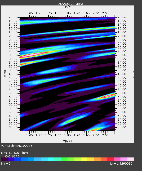
| Estimated Moho Depth: |
29.5 km |
| Estimated Crust Vp/Vs: |
1.67 |
| Assumed Crust Vp: |
6.391 km/s |
| Estimated Crust Vs: |
3.832 km/s |
| Estimated Crust Poisson's Ratio: |
0.22 |
|
| Radial Match: |
86.100235 % |
| Radial Bump: |
400 |
| Transverse Match: |
84.65143 % |
| Transverse Bump: |
400 |
| SOD ConfigId: |
16820 |
| Insert Time: |
2010-03-08 23:26:25.361 +0000 |
| GWidth: |
2.5 |
| Max Bumps: |
400 |
| Tol: |
0.001 |
|

Signal To Noise
| Channel | StoN | STA | LTA |
| XN:STGI: :BHZ:20020401T20:11:03.425007Z | 1.8401043 | 1.2514582E-6 | 6.801018E-7 |
| XN:STGI: :BHN:20020401T20:11:03.425007Z | 3.2255719 | 1.3691196E-6 | 4.244579E-7 |
| XN:STGI: :BHE:20020401T20:11:03.425007Z | 10.283617 | 3.93837E-6 | 3.8297517E-7 |
| Arrivals |
| Ps | 3.2 SECOND |
| PpPs | 12 SECOND |
| PsPs/PpSs | 15 SECOND |


