You are here: Home > Network List > TA - USArray Transportable Network (new EarthScope stations) Stations List
> Station C16K Lisburne Hills, AK, USA > Earthquake Result Viewer
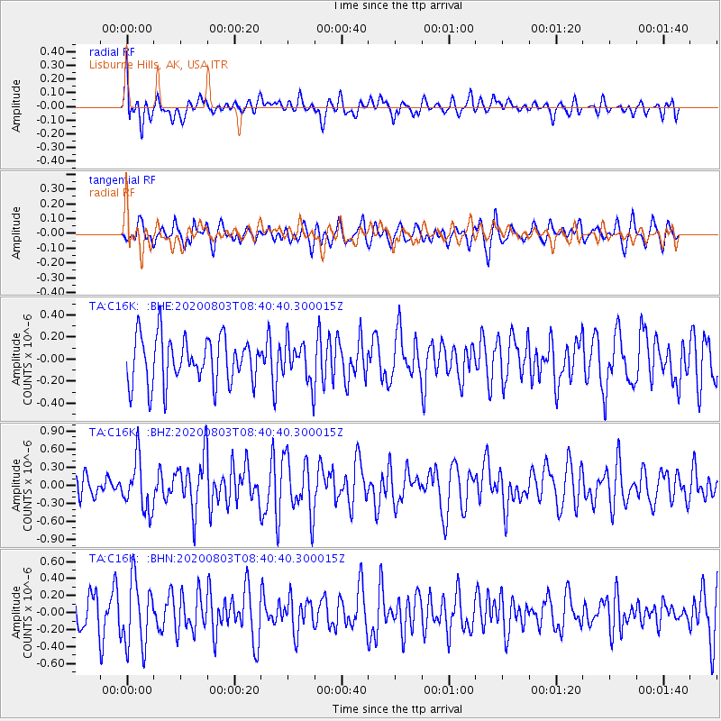
C16K Lisburne Hills, AK, USA - Earthquake Result Viewer
*The percent match for this event was below the threshold and hence no stack was calculated.
| Earthquake location: |
Mariana Islands Region |
| Earthquake latitude/longitude: |
17.1/147.3 |
| Earthquake time(UTC): |
2020/08/03 (216) 08:31:10 GMT |
| Earthquake Depth: |
10 km |
| Earthquake Magnitude: |
5.6 mww |
| Earthquake Catalog/Contributor: |
NEIC PDE/us |
|
| Network: |
TA USArray Transportable Network (new EarthScope stations) |
| Station: |
C16K Lisburne Hills, AK, USA |
| Lat/Lon: |
68.27 N/165.34 W |
| Elevation: |
102 m |
|
| Distance: |
59.2 deg |
| Az: |
18.584 deg |
| Baz: |
234.963 deg |
| Ray Param: |
$rayparam |
*The percent match for this event was below the threshold and hence was not used in the summary stack. |
|
| Radial Match: |
59.068645 % |
| Radial Bump: |
400 |
| Transverse Match: |
49.311764 % |
| Transverse Bump: |
398 |
| SOD ConfigId: |
21709731 |
| Insert Time: |
2020-08-17 08:45:50.118 +0000 |
| GWidth: |
2.5 |
| Max Bumps: |
400 |
| Tol: |
0.001 |
|
Signal To Noise
| Channel | StoN | STA | LTA |
| TA:C16K: :BHZ:20200803T08:40:40.300015Z | 2.055969 | 4.237996E-7 | 2.0613133E-7 |
| TA:C16K: :BHN:20200803T08:40:40.300015Z | 1.6514837 | 3.9314784E-7 | 2.3805735E-7 |
| TA:C16K: :BHE:20200803T08:40:40.300015Z | 0.8623045 | 1.8255639E-7 | 2.1170757E-7 |
| Arrivals |
| Ps | |
| PpPs | |
| PsPs/PpSs | |


