You are here: Home > Network List > TA - USArray Transportable Network (new EarthScope stations) Stations List
> Station C19K Lookout Ridge, AK, USA > Earthquake Result Viewer
C19K Lookout Ridge, AK, USA - Earthquake Result Viewer
| Earthquake location: |
Mariana Islands Region |
| Earthquake latitude/longitude: |
17.1/147.3 |
| Earthquake time(UTC): |
2020/08/03 (216) 08:31:10 GMT |
| Earthquake Depth: |
10 km |
| Earthquake Magnitude: |
5.6 mww |
| Earthquake Catalog/Contributor: |
NEIC PDE/us |
|
| Network: |
TA USArray Transportable Network (new EarthScope stations) |
| Station: |
C19K Lookout Ridge, AK, USA |
| Lat/Lon: |
69.10 N/159.59 W |
| Elevation: |
745 m |
|
| Distance: |
61.4 deg |
| Az: |
19.064 deg |
| Baz: |
240.559 deg |
| Ray Param: |
0.060886156 |
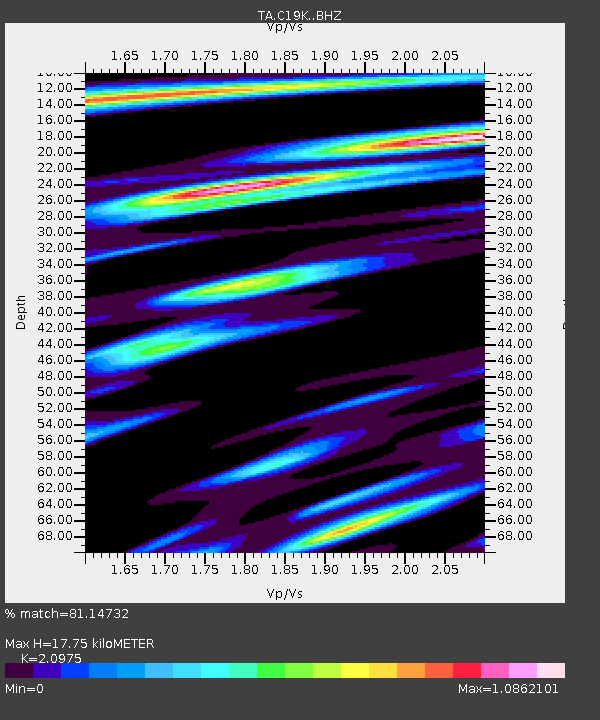
| Estimated Moho Depth: |
17.75 km |
| Estimated Crust Vp/Vs: |
2.10 |
| Assumed Crust Vp: |
6.221 km/s |
| Estimated Crust Vs: |
2.966 km/s |
| Estimated Crust Poisson's Ratio: |
0.35 |
|
| Radial Match: |
81.14732 % |
| Radial Bump: |
400 |
| Transverse Match: |
73.65081 % |
| Transverse Bump: |
400 |
| SOD ConfigId: |
21709731 |
| Insert Time: |
2020-08-17 08:45:53.304 +0000 |
| GWidth: |
2.5 |
| Max Bumps: |
400 |
| Tol: |
0.001 |
|

Signal To Noise
| Channel | StoN | STA | LTA |
| TA:C19K: :BHZ:20200803T08:40:55.475002Z | 3.425443 | 4.4225646E-7 | 1.2910928E-7 |
| TA:C19K: :BHN:20200803T08:40:55.475002Z | 1.0212424 | 8.398553E-8 | 8.223859E-8 |
| TA:C19K: :BHE:20200803T08:40:55.475002Z | 1.1130029 | 1.0661187E-7 | 9.57876E-8 |
| Arrivals |
| Ps | 3.2 SECOND |
| PpPs | 8.5 SECOND |
| PsPs/PpSs | 12 SECOND |


