You are here: Home > Network List > TA - USArray Transportable Network (new EarthScope stations) Stations List
> Station H20K Anotleneega Mountain, AK, USA > Earthquake Result Viewer
H20K Anotleneega Mountain, AK, USA - Earthquake Result Viewer
| Earthquake location: |
Mariana Islands Region |
| Earthquake latitude/longitude: |
17.1/147.3 |
| Earthquake time(UTC): |
2020/08/03 (216) 08:31:10 GMT |
| Earthquake Depth: |
10 km |
| Earthquake Magnitude: |
5.6 mww |
| Earthquake Catalog/Contributor: |
NEIC PDE/us |
|
| Network: |
TA USArray Transportable Network (new EarthScope stations) |
| Station: |
H20K Anotleneega Mountain, AK, USA |
| Lat/Lon: |
65.49 N/154.88 W |
| Elevation: |
514 m |
|
| Distance: |
61.5 deg |
| Az: |
23.688 deg |
| Baz: |
247.111 deg |
| Ray Param: |
0.06085959 |
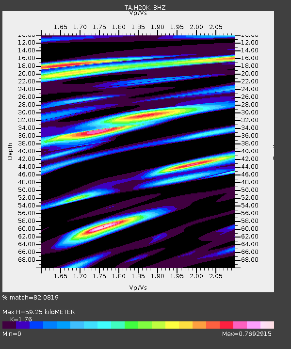
| Estimated Moho Depth: |
59.25 km |
| Estimated Crust Vp/Vs: |
1.76 |
| Assumed Crust Vp: |
6.566 km/s |
| Estimated Crust Vs: |
3.731 km/s |
| Estimated Crust Poisson's Ratio: |
0.26 |
|
| Radial Match: |
82.0819 % |
| Radial Bump: |
400 |
| Transverse Match: |
67.43279 % |
| Transverse Bump: |
400 |
| SOD ConfigId: |
21709731 |
| Insert Time: |
2020-08-17 08:47:06.061 +0000 |
| GWidth: |
2.5 |
| Max Bumps: |
400 |
| Tol: |
0.001 |
|

Signal To Noise
| Channel | StoN | STA | LTA |
| TA:H20K: :BHZ:20200803T08:40:55.750027Z | 2.5699267 | 2.1740962E-7 | 8.45976E-8 |
| TA:H20K: :BHN:20200803T08:40:55.750027Z | 0.6752436 | 5.0295036E-8 | 7.4484284E-8 |
| TA:H20K: :BHE:20200803T08:40:55.750027Z | 2.303553 | 1.5463071E-7 | 6.712704E-8 |
| Arrivals |
| Ps | 7.2 SECOND |
| PpPs | 24 SECOND |
| PsPs/PpSs | 31 SECOND |


