You are here: Home > Network List > TA - USArray Transportable Network (new EarthScope stations) Stations List
> Station H31M Peel River, Yukon, CAN > Earthquake Result Viewer
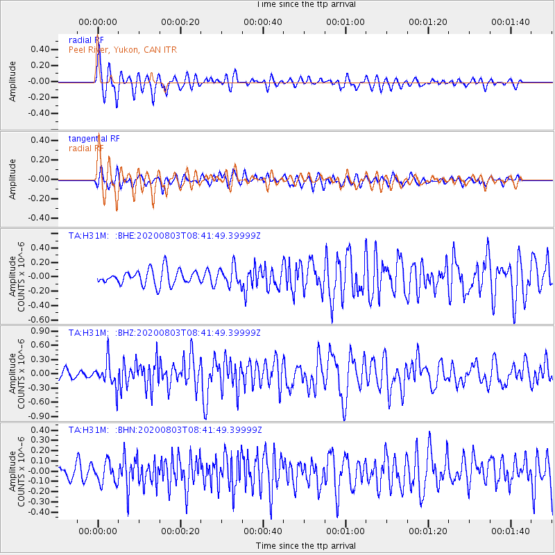
H31M Peel River, Yukon, CAN - Earthquake Result Viewer
*The percent match for this event was below the threshold and hence no stack was calculated.
| Earthquake location: |
Mariana Islands Region |
| Earthquake latitude/longitude: |
17.1/147.3 |
| Earthquake time(UTC): |
2020/08/03 (216) 08:31:10 GMT |
| Earthquake Depth: |
10 km |
| Earthquake Magnitude: |
5.6 mww |
| Earthquake Catalog/Contributor: |
NEIC PDE/us |
|
| Network: |
TA USArray Transportable Network (new EarthScope stations) |
| Station: |
H31M Peel River, Yukon, CAN |
| Lat/Lon: |
65.81 N/134.34 W |
| Elevation: |
642 m |
|
| Distance: |
69.8 deg |
| Az: |
25.474 deg |
| Baz: |
266.574 deg |
| Ray Param: |
$rayparam |
*The percent match for this event was below the threshold and hence was not used in the summary stack. |
|
| Radial Match: |
70.187096 % |
| Radial Bump: |
400 |
| Transverse Match: |
55.141857 % |
| Transverse Bump: |
400 |
| SOD ConfigId: |
21709731 |
| Insert Time: |
2020-08-17 08:47:11.550 +0000 |
| GWidth: |
2.5 |
| Max Bumps: |
400 |
| Tol: |
0.001 |
|
Signal To Noise
| Channel | StoN | STA | LTA |
| TA:H31M: :BHZ:20200803T08:41:49.39999Z | 3.2654858 | 2.8788122E-7 | 8.815877E-8 |
| TA:H31M: :BHN:20200803T08:41:49.39999Z | 1.3844248 | 1.0269084E-7 | 7.417582E-8 |
| TA:H31M: :BHE:20200803T08:41:49.39999Z | 1.2723786 | 1.2895211E-7 | 1.0134728E-7 |
| Arrivals |
| Ps | |
| PpPs | |
| PsPs/PpSs | |


