You are here: Home > Network List > US - United States National Seismic Network Stations List
> Station LAO LASA Array, Montana, USA > Earthquake Result Viewer
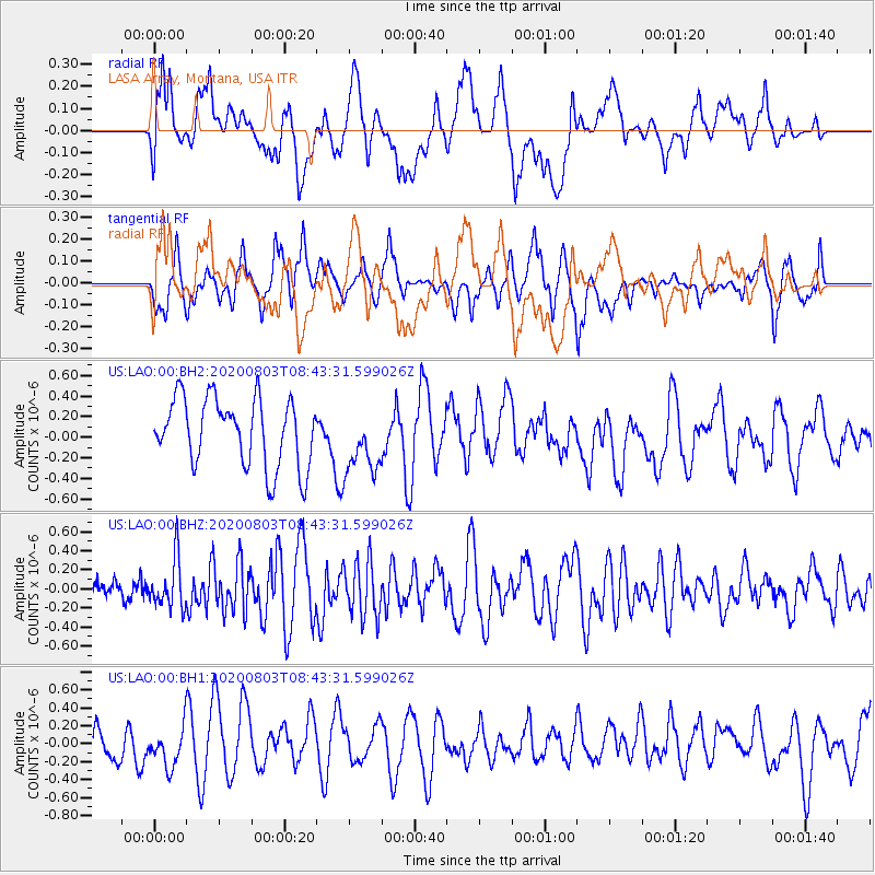
LAO LASA Array, Montana, USA - Earthquake Result Viewer
*The percent match for this event was below the threshold and hence no stack was calculated.
| Earthquake location: |
Mariana Islands Region |
| Earthquake latitude/longitude: |
17.1/147.3 |
| Earthquake time(UTC): |
2020/08/03 (216) 08:31:10 GMT |
| Earthquake Depth: |
10 km |
| Earthquake Magnitude: |
5.6 mww |
| Earthquake Catalog/Contributor: |
NEIC PDE/us |
|
| Network: |
US United States National Seismic Network |
| Station: |
LAO LASA Array, Montana, USA |
| Lat/Lon: |
46.69 N/106.22 W |
| Elevation: |
902 m |
|
| Distance: |
88.6 deg |
| Az: |
41.333 deg |
| Baz: |
293.414 deg |
| Ray Param: |
$rayparam |
*The percent match for this event was below the threshold and hence was not used in the summary stack. |
|
| Radial Match: |
45.678967 % |
| Radial Bump: |
400 |
| Transverse Match: |
55.424465 % |
| Transverse Bump: |
400 |
| SOD ConfigId: |
21709731 |
| Insert Time: |
2020-08-17 08:49:38.779 +0000 |
| GWidth: |
2.5 |
| Max Bumps: |
400 |
| Tol: |
0.001 |
|
Signal To Noise
| Channel | StoN | STA | LTA |
| US:LAO:00:BHZ:20200803T08:43:31.599026Z | 2.5249982 | 2.5750873E-7 | 1.0198374E-7 |
| US:LAO:00:BH1:20200803T08:43:31.599026Z | 0.99979234 | 2.294703E-7 | 2.2951797E-7 |
| US:LAO:00:BH2:20200803T08:43:31.599026Z | 0.97076154 | 3.182502E-7 | 3.278356E-7 |
| Arrivals |
| Ps | |
| PpPs | |
| PsPs/PpSs | |


