You are here: Home > Network List > WY - Yellowstone Wyoming Seismic Network Stations List
> Station YHH Holmes Hill, YNP, WY, USA > Earthquake Result Viewer
YHH Holmes Hill, YNP, WY, USA - Earthquake Result Viewer
| Earthquake location: |
Mariana Islands Region |
| Earthquake latitude/longitude: |
17.1/147.3 |
| Earthquake time(UTC): |
2020/08/03 (216) 08:31:10 GMT |
| Earthquake Depth: |
10 km |
| Earthquake Magnitude: |
5.6 mww |
| Earthquake Catalog/Contributor: |
NEIC PDE/us |
|
| Network: |
WY Yellowstone Wyoming Seismic Network |
| Station: |
YHH Holmes Hill, YNP, WY, USA |
| Lat/Lon: |
44.79 N/110.85 W |
| Elevation: |
2717 m |
|
| Distance: |
86.3 deg |
| Az: |
44.304 deg |
| Baz: |
290.244 deg |
| Ray Param: |
0.04418473 |
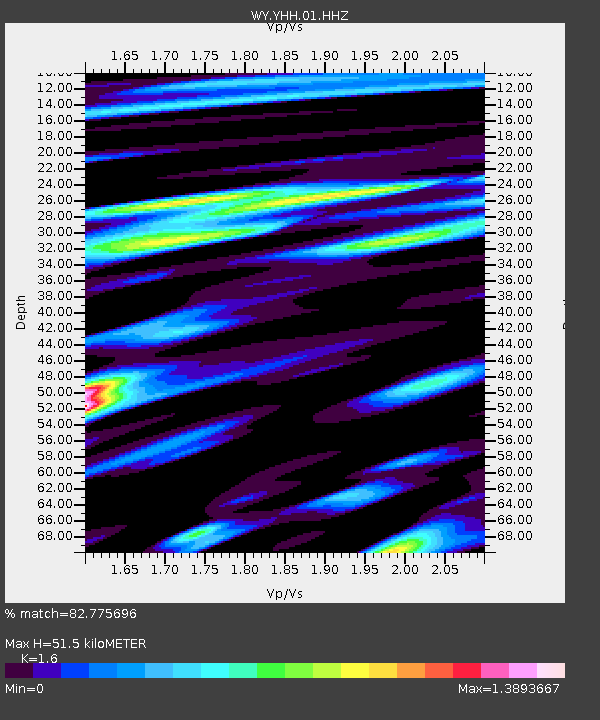
| Estimated Moho Depth: |
51.5 km |
| Estimated Crust Vp/Vs: |
1.60 |
| Assumed Crust Vp: |
6.35 km/s |
| Estimated Crust Vs: |
3.969 km/s |
| Estimated Crust Poisson's Ratio: |
0.18 |
|
| Radial Match: |
82.775696 % |
| Radial Bump: |
400 |
| Transverse Match: |
70.13147 % |
| Transverse Bump: |
400 |
| SOD ConfigId: |
21709731 |
| Insert Time: |
2020-08-17 08:51:29.525 +0000 |
| GWidth: |
2.5 |
| Max Bumps: |
400 |
| Tol: |
0.001 |
|
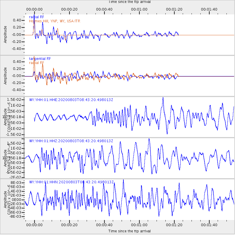
Signal To Noise
| Channel | StoN | STA | LTA |
| WY:YHH:01:HHZ:20200803T08:43:20.498013Z | 3.2070649 | 5.297082E-9 | 1.6516916E-9 |
| WY:YHH:01:HHN:20200803T08:43:20.498013Z | 1.972685 | 2.6836688E-9 | 1.3604143E-9 |
| WY:YHH:01:HHE:20200803T08:43:20.498013Z | 1.8566241 | 3.161369E-9 | 1.702751E-9 |
| Arrivals |
| Ps | 5.0 SECOND |
| PpPs | 21 SECOND |
| PsPs/PpSs | 26 SECOND |


