You are here: Home > Network List > WY - Yellowstone Wyoming Seismic Network Stations List
> Station YNR Norris Junction, YNP, WY, USA > Earthquake Result Viewer
YNR Norris Junction, YNP, WY, USA - Earthquake Result Viewer
| Earthquake location: |
Mariana Islands Region |
| Earthquake latitude/longitude: |
17.1/147.3 |
| Earthquake time(UTC): |
2020/08/03 (216) 08:31:10 GMT |
| Earthquake Depth: |
10 km |
| Earthquake Magnitude: |
5.6 mww |
| Earthquake Catalog/Contributor: |
NEIC PDE/us |
|
| Network: |
WY Yellowstone Wyoming Seismic Network |
| Station: |
YNR Norris Junction, YNP, WY, USA |
| Lat/Lon: |
44.72 N/110.68 W |
| Elevation: |
2336 m |
|
| Distance: |
86.4 deg |
| Az: |
44.33 deg |
| Baz: |
290.366 deg |
| Ray Param: |
0.0440833 |
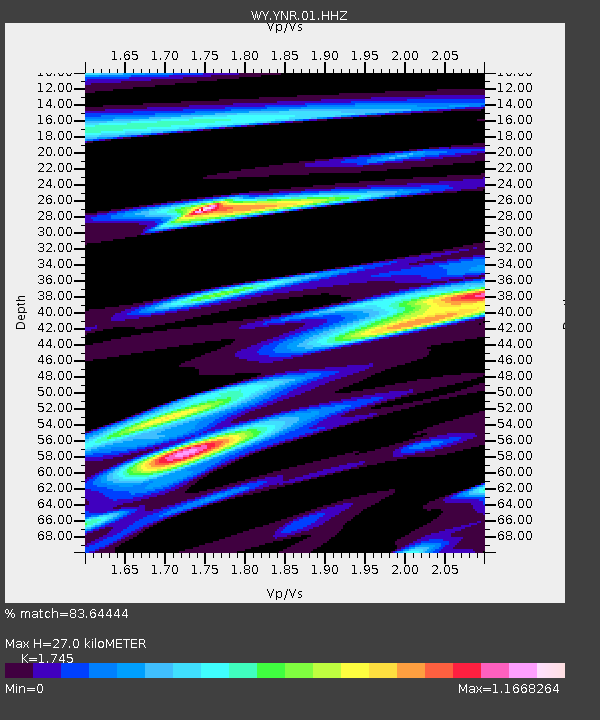
| Estimated Moho Depth: |
27.0 km |
| Estimated Crust Vp/Vs: |
1.75 |
| Assumed Crust Vp: |
6.35 km/s |
| Estimated Crust Vs: |
3.639 km/s |
| Estimated Crust Poisson's Ratio: |
0.26 |
|
| Radial Match: |
83.64444 % |
| Radial Bump: |
400 |
| Transverse Match: |
72.34696 % |
| Transverse Bump: |
400 |
| SOD ConfigId: |
21709731 |
| Insert Time: |
2020-08-17 08:51:37.157 +0000 |
| GWidth: |
2.5 |
| Max Bumps: |
400 |
| Tol: |
0.001 |
|

Signal To Noise
| Channel | StoN | STA | LTA |
| WY:YNR:01:HHZ:20200803T08:43:21.188015Z | 3.1778584 | 5.9277405E-9 | 1.8653257E-9 |
| WY:YNR:01:HHN:20200803T08:43:21.188015Z | 0.94619435 | 2.2090856E-9 | 2.3347058E-9 |
| WY:YNR:01:HHE:20200803T08:43:21.188015Z | 1.1937104 | 2.9024754E-9 | 2.4314737E-9 |
| Arrivals |
| Ps | 3.2 SECOND |
| PpPs | 11 SECOND |
| PsPs/PpSs | 15 SECOND |


